Malanghero geodata
Malanghero (Piedmont) is a populated place; located in Italy in Europe/Rome (GMT+2) time zone. With population of 574 people, there are 9230 cities with bigger population in this country. Compared to other cities in Italy, 65% of cities are located further ↓South; 96.6% of cities are located further →East and 58.2% of cities have lower elevation than Malanghero. Note1


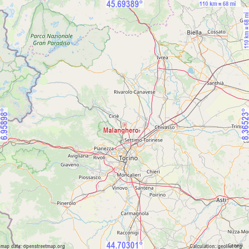
Malanghero GPS coordinates[2]
45° 12' 2.196" North, 7° 39' 43.56" East
| Map corner | latitude | longitude |
|---|---|---|
| Upper-left | 45.69389°, | 6.95898° |
| Center: | 45.20061°, | 7.6621° |
| Lower-right: | 44.70301°, | 8.36523° |
| Map W x H: | 110.2×110.2 km | = 68.5×68.5mi |
| max Lat: | 47.04031° ⇑35% North |
| Malanghero: | 45.20061° |
| min Lat: | ⇓65% South 35.50142° |
| min Long | Malanghero | max Long |
| 6.69888° | 7.6621° | 18.48682° |
| W 3.4%⇐ | ⇒96.6% E |
Elevation
Elevation of Malanghero is 287 m = 942 ft, and this is 19.7 m = 65 ft below average elevation for this country.
| Max E: |
2085 m = 6841 ft | 41.8% |
| Avg. | 306.7 m = 1006 ft | |
| Malanghero | 287 m = 942 ft | |
Min E: |
-4 m = -13 ft | 58.2% |
See also: Italy elevation on elevation.city.
Geographical zone
Malanghero is located in North temperate zone (between Tropic of Cancer and the Arctic Circle). Distance of this North polar circle is 2375.3 km =1475.9 mi to North.| Distance of | km | miles | from Malanghero |
|---|---|---|---|
| North Pole | 4981.2 | 3095.2 | to North |
| Arctic Circle | 2375.3 | 1475.9 | to North |
| Tropic Cancer | 2419.9 | 1503.7 | to South |
| Equator | 5025.8 | 3122.9 | to South |


Nearby cities:
15 places around Malanghero: (largest is in red/bold)
• Borgaro Torinese
5.5 km =3.4 mi,  185°
185°
• Caselle Torinese
3.3 km =2.1 mi,  207°
207°
• Ciriè
6.1 km =3.8 mi,  308°
308°
• Front
8.8 km =5.5 mi,  1°
1°
• Leini
4.5 km =2.8 mi,  115°
115°
• Lombardore
7.1 km =4.4 mi,  56°
56°
• Mappano
6.8 km =4.2 mi,  148°
148°
• Nole
8.5 km =5.3 mi,  302°
302°
• Rivarossa
7.1 km =4.4 mi,  39°
39°
• Robassomero
7.4 km =4.6 mi,  268°
268°
• San Carlo Canavese
6.6 km =4.1 mi,  317°
317°
• San Francesco al Campo
3 km =1.9 mi,  349°
349°
• San Maurizio
3.1 km =1.9 mi, 306°
• Venaria Reale
8.6 km =5.3 mi,  196°
196°
• Volpiano
8.9 km =5.5 mi,  90°
90°
Sources, notices
• [Note1] Compared only with cities in Italy existing in our database
• [Src1] Map data: © OpenStreetMap contributors (CC-BY-SA)
• [Src2] Other city data from geonames.org with taken over terms of usage.
• [Src3] Geographical zone / Annual Mean Temperature by Robert A. Rohde @ Wikipedia
