Corleto Monforte geodata
Corleto Monforte (Campania) is a seat of a third-order administrative division; located in Italy in Europe/Rome (GMT+2) time zone. With population of 623 people, there are 8818 cities with bigger population in this country. Compared to other cities in Italy, 84.5% of cities are located further ↑North; 90.1% of cities are located further ←West and 85.8% of cities have lower elevation than Corleto Monforte. Note1
Administrative division(s):
- Level 1: Campania
- Level 2: Provincia di Salerno
- Level 3: Corleto Monforte


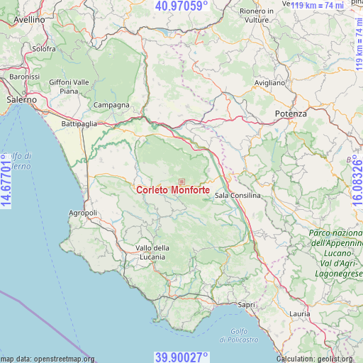
Corleto Monforte GPS coordinates[2]
40° 26' 15.216" North, 15° 22' 48.468" East
| Map corner | latitude | longitude |
|---|---|---|
| Upper-left | 40.97059°, | 14.67701° |
| Center: | 40.43756°, | 15.38013° |
| Lower-right: | 39.90027°, | 16.08326° |
| Map W x H: | 119×119 km | = 73.9×73.9mi |
| max Lat: | 47.04031° ⇑84.5% North |
| Corleto Monforte: | 40.43756° |
| min Lat: | ⇓15.5% South 35.50142° |
| min Long | Corleto Monfort | max Long |
| 6.69888° | 15.38013° | 18.48682° |
| W 90.1%⇐ | ⇒9.9% E |
Elevation
Elevation of Corleto Monforte is 629 m = 2064 ft, and this is 322.3 m = 1057 ft above average elevation for this country.
| Max E: |
2085 m = 6841 ft | 14.2% |
| Corleto Monforte | 629 m 2064 ft | |
| Avg. | 306.7 m = 1006 ft | |
Min E: |
-4 m = -13 ft | 85.8% |
See also: Italy elevation on elevation.city.
Geographical zone
Corleto Monforte is located in North temperate zone (between Tropic of Cancer and the Arctic Circle). Distance of this Northern Tropic circle is 1890.3 km =1174.6 mi to South.| Distance of | km | miles | from Corleto Monforte |
|---|---|---|---|
| North Pole | 5510.8 | 3424.3 | to North |
| Arctic Circle | 2904.9 | 1805 | to North |
| Tropic Cancer | 1890.3 | 1174.6 | to South |
| Equator | 4496.2 | 2793.8 | to South |


Nearby cities:
15 places around Corleto Monforte: (largest is in red/bold)
• Aquara
10.7 km =6.6 mi,  273°
273°
• Bellosguardo
6 km =3.7 mi,  253°
253°
• Fontana Vaglio
9.5 km =5.9 mi,  104°
104°
• Laurino
11.5 km =7.1 mi,  198°
198°
• Ottati
6.2 km =3.9 mi,  297°
297°
• Petina
10.5 km =6.5 mi,  356°
356°
• Piaggine
10.3 km =6.4 mi,  181°
181°
• Roscigno
5.1 km =3.2 mi,  214°
214°
• Sacco
6.8 km =4.2 mi, 181°
• San Pietro al Tanagro
9.2 km =5.7 mi,  77°
77°
• San Rufo
7.1 km =4.4 mi,  92°
92°
• Sant'Angelo A Fasanella
4 km =2.5 mi, 303°
• Sant'Arsenio
9.5 km =5.9 mi,  67°
67°
• Valle dell'Angelo
10.5 km =6.5 mi,  185°
185°
• Villa Littorio
8.7 km =5.4 mi, 204°
Sources, notices
• [Note1] Compared only with cities in Italy existing in our database
• [Src1] Map data: © OpenStreetMap contributors (CC-BY-SA)
• [Src2] Other city data from geonames.org with taken over terms of usage.
• [Src3] Geographical zone / Annual Mean Temperature by Robert A. Rohde @ Wikipedia
