Piaggine geodata
Piaggine (Campania) is a seat of a third-order administrative division; located in Italy in Europe/Rome (GMT+2) time zone. With population of 1,298 people, there are 5640 cities with bigger population in this country. Compared to other cities in Italy, 85.2% of cities are located further ↑North; 90.1% of cities are located further ←West and 85.7% of cities have lower elevation than Piaggine. Note1


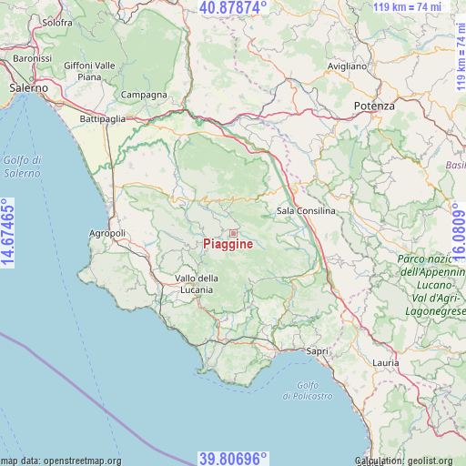
Piaggine GPS coordinates[2]
40° 20' 41.928" North, 15° 22' 39.972" East
| Map corner | latitude | longitude |
|---|---|---|
| Upper-left | 40.87874°, | 14.67465° |
| Center: | 40.34498°, | 15.37777° |
| Lower-right: | 39.80696°, | 16.0809° |
| Map W x H: | 119.2×119.2 km | = 74.1×74.1mi |
| max Lat: | 47.04031° ⇑85.2% North |
| Piaggine: | 40.34498° |
| min Lat: | ⇓14.8% South 35.50142° |
| min Long | Piaggine | max Long |
| 6.69888° | 15.37777° | 18.48682° |
| W 90.1%⇐ | ⇒9.9% E |
Elevation
Elevation of Piaggine is 625 m = 2051 ft, and this is 318.3 m = 1044 ft above average elevation for this country.
| Max E: |
2085 m = 6841 ft | 14.3% |
| Piaggine | 625 m 2051 ft | |
| Avg. | 306.7 m = 1006 ft | |
Min E: |
-4 m = -13 ft | 85.7% |
See also: Italy elevation on elevation.city.
Geographical zone
Piaggine is located in North temperate zone (between Tropic of Cancer and the Arctic Circle). Distance of this Northern Tropic circle is 1880 km =1168.2 mi to South.| Distance of | km | miles | from Piaggine |
|---|---|---|---|
| North Pole | 5521.1 | 3430.7 | to North |
| Arctic Circle | 2915.2 | 1811.4 | to North |
| Tropic Cancer | 1880 | 1168.2 | to South |
| Equator | 4485.9 | 2787.4 | to South |


Nearby cities:
15 places around Piaggine: (largest is in red/bold)
• Bellosguardo
10.2 km =6.3 mi,  327°
327°
• Campora
8.5 km =5.3 mi,  238°
238°
• Cannalonga
13.3 km =8.3 mi,  212°
212°
• Corleto Monforte
10.3 km =6.4 mi,  1°
1°
• Felitto
11.8 km =7.3 mi,  285°
285°
• Fontana Vaglio
12.3 km =7.6 mi,  50°
50°
• Laurino
3.4 km =2.1 mi,  259°
259°
• Magliano Vetere
12 km =7.5 mi,  271°
271°
• Roscigno
6.7 km =4.2 mi,  336°
336°
• Sacco
3.5 km =2.2 mi, 0°
• San Rufo
12.3 km =7.6 mi,  36°
36°
• Sant'Angelo A Fasanella
12.9 km =8 mi,  345°
345°
• Stio
11.4 km =7.1 mi,  250°
250°
• Valle dell'Angelo
0.8 km =0.5 mi, 260°
• Villa Littorio
4.2 km =2.6 mi,  304°
304°
Sources, notices
• [Note1] Compared only with cities in Italy existing in our database
• [Src1] Map data: © OpenStreetMap contributors (CC-BY-SA)
• [Src2] Other city data from geonames.org with taken over terms of usage.
• [Src3] Geographical zone / Annual Mean Temperature by Robert A. Rohde @ Wikipedia
