Levate geodata
Levate (Lombardy) is a seat of a third-order administrative division; located in Italy in Europe/Rome (GMT+2) time zone. With population of 3,253 people, there are 2870 cities with bigger population in this country. Compared to other cities in Italy, 78% of cities are located further ↓South; 71.6% of cities are located further →East and 57.2% of cities have higher elevation than Levate. Note1


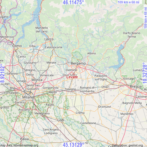
Levate GPS coordinates[2]
45° 37' 30.648" North, 9° 37' 26.94" East
| Map corner | latitude | longitude |
|---|---|---|
| Upper-left | 46.11475°, | 8.92102° |
| Center: | 45.62518°, | 9.62415° |
| Lower-right: | 45.13129°, | 10.32728° |
| Map W x H: | 109.4×109.3 km | = 68×67.9mi |
| max Lat: | 47.04031° ⇑22% North |
| Levate: | 45.62518° |
| min Lat: | ⇓78% South 35.50142° |
| min Long | Levate | max Long |
| 6.69888° | 9.62415° | 18.48682° |
| W 28.4%⇐ | ⇒71.6% E |
Elevation
Elevation of Levate is 186 m = 610 ft, and this is 120.7 m = 396 ft below average elevation for this country.
| Max E: |
2085 m = 6841 ft | 57.2% |
| Avg. | 306.7 m = 1006 ft | |
| Levate | 186 m = 610 ft | |
Min E: |
-4 m = -13 ft | 42.8% |
See also: Italy elevation on elevation.city.
Geographical zone
Levate is located in North temperate zone (between Tropic of Cancer and the Arctic Circle). Distance of this North polar circle is 2328.1 km =1446.6 mi to North.| Distance of | km | miles | from Levate |
|---|---|---|---|
| North Pole | 4934 | 3065.8 | to North |
| Arctic Circle | 2328.1 | 1446.6 | to North |
| Tropic Cancer | 2467.1 | 1533 | to South |
| Equator | 5073 | 3152.2 | to South |


Nearby cities:
15 places around Levate: (largest is in red/bold)
• Arcene
5.4 km =3.4 mi,  187°
187°
• Azzano San Paolo
5.3 km =3.3 mi,  46°
46°
• Boltiere
4.5 km =2.8 mi,  232°
232°
• Ciserano
4.5 km =2.8 mi,  203°
203°
• Comun Nuovo
3 km =1.9 mi,  94°
94°
• Dalmine
3 km =1.9 mi,  332°
332°
• Lallio
4.2 km =2.6 mi,  5°
5°
• Marne
5.1 km =3.2 mi,  268°
268°
• Osio Sopra
3.1 km =1.9 mi,  278°
278°
• Osio Sotto
2.9 km =1.8 mi,  249°
249°
• Pognano
4.5 km =2.8 mi,  164°
164°
• Stezzano
3.5 km =2.2 mi,  38°
38°
• Verdellino
3 km =1.9 mi,  205°
205°
• Verdello
2.4 km =1.5 mi,  171°
171°
• Zanica
5.1 km =3.2 mi,  69°
69°
Sources, notices
• [Note1] Compared only with cities in Italy existing in our database
• [Src1] Map data: © OpenStreetMap contributors (CC-BY-SA)
• [Src2] Other city data from geonames.org with taken over terms of usage.
• [Src3] Geographical zone / Annual Mean Temperature by Robert A. Rohde @ Wikipedia
