Isola Vicentina geodata
Isola Vicentina (Veneto) is a seat of a third-order administrative division; located in Italy in Europe/Rome (GMT+2) time zone. With population of 4,340 people, there are 2218 cities with bigger population in this country. Compared to other cities in Italy, 78.2% of cities are located further ↓South; 51.3% of cities are located further →East and 74.7% of cities have higher elevation than Isola Vicentina. Note1


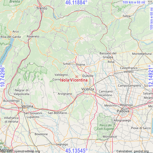
Isola Vicentina GPS coordinates[2]
45° 37' 45.48" North, 11° 26' 45.888" East
| Map corner | latitude | longitude |
|---|---|---|
| Upper-left | 46.11884°, | 10.74296° |
| Center: | 45.6293°, | 11.44608° |
| Lower-right: | 45.13545°, | 12.14921° |
| Map W x H: | 109.3×109.3 km | = 67.9×67.9mi |
| max Lat: | 47.04031° ⇑21.8% North |
| Isola Vicentina: | 45.6293° |
| min Lat: | ⇓78.2% South 35.50142° |
| min Long | Isola Vicentina | max Long |
| 6.69888° | 11.44608° | 18.48682° |
| W 48.7%⇐ | ⇒51.3% E |
Elevation
Elevation of Isola Vicentina is 75 m = 246 ft, and this is 231.7 m = 760 ft below average elevation for this country.
| Max E: |
2085 m = 6841 ft | 74.7% |
| Avg. | 306.7 m = 1006 ft | |
| Isola Vicentina | 75 m = 246 ft | |
Min E: |
-4 m = -13 ft | 25.3% |
See also: Italy elevation on elevation.city.
Geographical zone
Isola Vicentina is located in North temperate zone (between Tropic of Cancer and the Arctic Circle). Distance of this North polar circle is 2327.7 km =1446.4 mi to North.| Distance of | km | miles | from Isola Vicentina |
|---|---|---|---|
| North Pole | 4933.6 | 3065.6 | to North |
| Arctic Circle | 2327.7 | 1446.4 | to North |
| Tropic Cancer | 2467.6 | 1533.3 | to South |
| Equator | 5073.5 | 3152.5 | to South |


Nearby cities:
15 places around Isola Vicentina: (largest is in red/bold)
• Caldogno-Rettorgole-Cresole
5 km =3.1 mi,  118°
118°
• Castelgomberto
6.8 km =4.2 mi,  220°
220°
• Castelnovo
1.8 km =1.1 mi,  145°
145°
• Cereda-Cozza Cornedo
6.8 km =4.2 mi,  243°
243°
• Costabissara
6 km =3.7 mi, 149°
• Crispi Cavour
6.8 km =4.2 mi,  140°
140°
• Gambugliano
4.6 km =2.9 mi,  187°
187°
• Malo
4.1 km =2.5 mi,  324°
324°
• Monte di Malo
7.4 km =4.6 mi,  297°
297°
• Motta
5.5 km =3.4 mi,  133°
133°
• Novoledo
5.3 km =3.3 mi,  68°
68°
• Rozzampia
7.1 km =4.4 mi,  38°
38°
• Santo
5.9 km =3.7 mi,  32°
32°
• Valle
5.5 km =3.4 mi,  209°
209°
• Villaverla
4.2 km =2.6 mi,  57°
57°
Sources, notices
• [Note1] Compared only with cities in Italy existing in our database
• [Src1] Map data: © OpenStreetMap contributors (CC-BY-SA)
• [Src2] Other city data from geonames.org with taken over terms of usage.
• [Src3] Geographical zone / Annual Mean Temperature by Robert A. Rohde @ Wikipedia
