Sannicandro Garganico geodata
Sannicandro Garganico (Apulia) is a seat of a third-order administrative division; located in Italy in Europe/Rome (GMT+2) time zone. With population of 15,815 people, there are 576 cities with bigger population in this country. Compared to other cities in Italy, 71.7% of cities are located further ↑North; 90.9% of cities are located further ←West and 52.8% of cities have higher elevation than Sannicandro Garganico. Note1
Administrative division(s):
- Level 1: Apulia
- Level 2: Provincia di Foggia
- Level 3: San Nicandro Garganico
Current local time in Sannicandro Garganico:
07:52 PM, WednesdayDifference from your time zone: hours


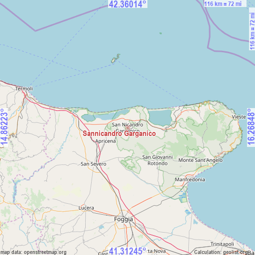
Sannicandro Garganico GPS coordinates[2]
41° 50' 18.384" North, 15° 33' 55.26" East
| Map corner | latitude | longitude |
|---|---|---|
| Upper-left | 42.36014°, | 14.86223° |
| Center: | 41.83844°, | 15.56535° |
| Lower-right: | 41.31245°, | 16.26848° |
| Map W x H: | 116.5×116.5 km | = 72.4×72.4mi |
| max Lat: | 47.04031° ⇑71.7% North |
| Sannicandro Garganico: | 41.83844° |
| min Lat: | ⇓28.3% South 35.50142° |
| min Long | Sannicandro Gar | max Long |
| 6.69888° | 15.56535° | 18.48682° |
| W 90.9%⇐ | ⇒9.1% E |
Elevation
Elevation of Sannicandro Garganico is 217 m = 712 ft, and this is 89.7 m = 294 ft below average elevation for this country.
| Max E: |
2085 m = 6841 ft | 52.8% |
| Avg. | 306.7 m = 1006 ft | |
| Sannicandro Garganico | 217 m = 712 ft | |
Min E: |
-4 m = -13 ft | 47.2% |
See also: Italy elevation on elevation.city.
Geographical zone
Sannicandro Garganico is located in North temperate zone (between Tropic of Cancer and the Arctic Circle). Distance of this Northern Tropic circle is 2046.1 km =1271.4 mi to South.| Distance of | km | miles | from Sannicandro Garganico |
|---|---|---|---|
| North Pole | 5355.1 | 3327.5 | to North |
| Arctic Circle | 2749.2 | 1708.3 | to North |
| Tropic Cancer | 2046.1 | 1271.4 | to South |
| Equator | 4652 | 2890.6 | to South |


Nearby cities:
15 places around Sannicandro Garganico: (largest is in red/bold)
• Apricena
11.6 km =7.2 mi,  240°
240°
• Borgo Celano
16.8 km =10.4 mi,  153°
153°
• Cagnano Varano
17.2 km =10.7 mi,  93°
93°
• Carpino
24.2 km =15 mi, 88°
• Ischitella
28.6 km =17.8 mi,  75°
75°
• Isole Tremiti
31.8 km =19.8 mi,  350°
350°
• Lesina
17.8 km =11.1 mi,  278°
278°
• Poggio Imperiale
16.5 km =10.3 mi,  264°
264°
• Rignano Garganico
17.8 km =11.1 mi,  173°
173°
• Rodi Garganico
28 km =17.4 mi,  69°
69°
• San Giovanni Rotondo
19.9 km =12.4 mi,  137°
137°
• San Marco in Lamis
15.3 km =9.5 mi,  156°
156°
• San Paolo di Civitate
27.6 km =17.1 mi,  246°
246°
• San Severo
22.8 km =14.2 mi,  221°
221°
• Torremaggiore
28 km =17.4 mi,  233°
233°
Sources, notices
• [Note1] Compared only with cities in Italy existing in our database
• [Src1] Map data: © OpenStreetMap contributors (CC-BY-SA)
• [Src2] Other city data from geonames.org with taken over terms of usage.
• [Src3] Geographical zone / Annual Mean Temperature by Robert A. Rohde @ Wikipedia
