Apricena geodata
Apricena (Apulia) is a seat of a third-order administrative division; located in Italy in Europe/Rome (GMT+2) time zone. With population of 13,195 people, there are 697 cities with bigger population in this country. Compared to other cities in Italy, 72.1% of cities are located further ↑North; 90.4% of cities are located further ←West and 74.9% of cities have higher elevation than Apricena. Note1


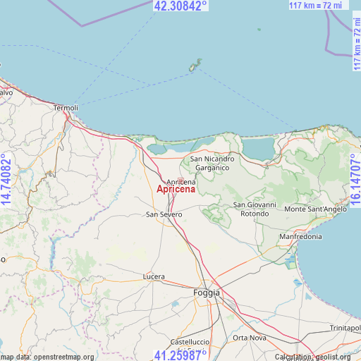
Apricena GPS coordinates[2]
41° 47' 10.644" North, 15° 26' 38.184" East
| Map corner | latitude | longitude |
|---|---|---|
| Upper-left | 42.30842°, | 14.74082° |
| Center: | 41.78629°, | 15.44394° |
| Lower-right: | 41.25987°, | 16.14707° |
| Map W x H: | 116.6×116.6 km | = 72.5×72.5mi |
| max Lat: | 47.04031° ⇑72.1% North |
| Apricena: | 41.78629° |
| min Lat: | ⇓27.9% South 35.50142° |
| min Long | Apricena | max Long |
| 6.69888° | 15.44394° | 18.48682° |
| W 90.4%⇐ | ⇒9.6% E |
Elevation
Elevation of Apricena is 74 m = 243 ft, and this is 232.7 m = 763 ft below average elevation for this country.
| Max E: |
2085 m = 6841 ft | 74.9% |
| Avg. | 306.7 m = 1006 ft | |
| Apricena | 74 m = 243 ft | |
Min E: |
-4 m = -13 ft | 25.1% |
See also: Italy elevation on elevation.city.
Geographical zone
Apricena is located in North temperate zone (between Tropic of Cancer and the Arctic Circle). Distance of this Northern Tropic circle is 2040.3 km =1267.8 mi to South.| Distance of | km | miles | from Apricena |
|---|---|---|---|
| North Pole | 5360.9 | 3331.1 | to North |
| Arctic Circle | 2755 | 1711.9 | to North |
| Tropic Cancer | 2040.3 | 1267.8 | to South |
| Equator | 4646.2 | 2887 | to South |


Nearby cities:
15 places around Apricena: (largest is in red/bold)
• Borgo Celano
20 km =12.4 mi,  117°
117°
• Cagnano Varano
27.6 km =17.1 mi,  80°
80°
• Casalnuovo Monterotaro
33.8 km =21 mi,  236°
236°
• Chieuti
23.9 km =14.9 mi,  285°
285°
• Lesina
11.2 km =7 mi,  317°
317°
• Lucera
32.4 km =20.1 mi,  195°
195°
• Poggio Imperiale
7.7 km =4.8 mi,  303°
303°
• Rignano Garganico
16.9 km =10.5 mi,  134°
134°
• San Giovanni Rotondo
25.2 km =15.7 mi,  110°
110°
• San Marco in Lamis
18.1 km =11.2 mi, 117°
• San Paolo di Civitate
16.1 km =10 mi,  250°
250°
• San Severo
12.3 km =7.6 mi, 204°
• Sannicandro Garganico
11.6 km =7.2 mi,  60°
60°
• Serracapriola
23.6 km =14.7 mi,  276°
276°
• Torremaggiore
16.5 km =10.3 mi,  228°
228°
Sources, notices
• [Note1] Compared only with cities in Italy existing in our database
• [Src1] Map data: © OpenStreetMap contributors (CC-BY-SA)
• [Src2] Other city data from geonames.org with taken over terms of usage.
• [Src3] Geographical zone / Annual Mean Temperature by Robert A. Rohde @ Wikipedia
