Poggi Inferiore Poggi Superiore geodata
Poggi Inferiore Poggi Superiore (Liguria) is a populated place; located in Italy in Europe/Rome (GMT+2) time zone. With population of 743 people, there are 7998 cities with bigger population in this country. Compared to other cities in Italy, 56% of cities are located further ↑North; 93.8% of cities are located further →East and 61.8% of cities have higher elevation than Poggi Inferiore Poggi Superiore. Note1
Current local time in Poggi Inferiore Poggi Superiore:
06:55 PM, WednesdayDifference from your time zone: hours


Poggi Inferiore Poggi Superiore GPS coordinates[2]
43° 52' 13.08" North, 7° 59' 2.292" East
| Map corner | latitude | longitude |
|---|---|---|
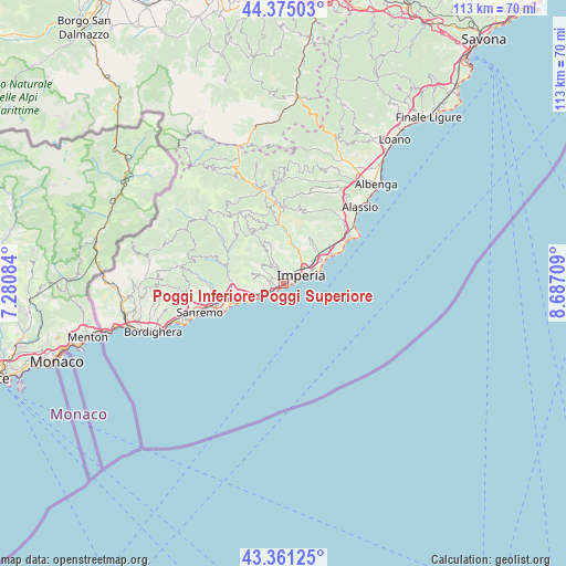
| Upper-left | 44.37503°, | 7.28084° |
| Center: | 43.8703°, | 7.98397° |
| Lower-right: | 43.36125°, | 8.68709° |
| Map W x H: | 112.7×112.7 km | = 70×70mi |
| max Lat: | 47.04031° ⇑56% North |
| Poggi Inferiore Poggi Superiore: | 43.8703° |
| min Lat: | ⇓44% South 35.50142° |
| min Long | Poggi Inferiore | max Long |
| 6.69888° | 7.98397° | 18.48682° |
| W 6.2%⇐ | ⇒93.8% E |
Elevation
Elevation of Poggi Inferiore Poggi Superiore is 150 m = 492 ft, and this is 156.7 m = 514 ft below average elevation for this country.
| Max E: |
2085 m = 6841 ft | 61.8% |
| Avg. | 306.7 m = 1006 ft | |
| Poggi Inferiore Poggi Superiore | 150 m = 492 ft | |
Min E: |
-4 m = -13 ft | 38.2% |
See also: Italy elevation on elevation.city.
Geographical zone
Poggi Inferiore Poggi Superiore is located in North temperate zone (between Tropic of Cancer and the Arctic Circle). Distance of this Northern Tropic circle is 2272 km =1411.8 mi to South.| Distance of | km | miles | from Poggi Inferiore Poggi Superiore |
|---|---|---|---|
| North Pole | 5129.1 | 3187.1 | to North |
| Arctic Circle | 2523.3 | 1567.9 | to North |
| Tropic Cancer | 2272 | 1411.8 | to South |
| Equator | 4877.9 | 3031 | to South |


Nearby cities:
15 places around Poggi Inferiore Poggi Superiore: (largest is in red/bold)
• Borgo Sant'Agata
4.2 km =2.6 mi,  29°
29°
• Cipressa
4.7 km =2.9 mi,  244°
244°
• Civezza
2.8 km =1.7 mi,  292°
292°
• Costarainera
3.8 km =2.4 mi, 243°
• Dolcedo
5 km =3.1 mi,  326°
326°
• Imperia
4.9 km =3 mi,  64°
64°
• Molini
7.2 km =4.5 mi, 329°
• Pietrabruna
6.8 km =4.2 mi, 288°
• Pompeiana
7.9 km =4.9 mi,  255°
255°
• Pontedassio
8 km =5 mi,  18°
18°
• Prelà Castello
8.4 km =5.2 mi,  337°
337°
• San Lorenzo al Mare
2.4 km =1.5 mi,  220°
220°
• Santo Stefano al Mare
7.8 km =4.8 mi, 243°
• Terzorio
7.1 km =4.4 mi,  253°
253°
• Vasia
7.3 km =4.5 mi, 340°
Sources, notices
• [Note1] Compared only with cities in Italy existing in our database
• [Src1] Map data: © OpenStreetMap contributors (CC-BY-SA)
• [Src2] Other city data from geonames.org with taken over terms of usage.
• [Src3] Geographical zone / Annual Mean Temperature by Robert A. Rohde @ Wikipedia
