Vasia geodata
Vasia (Liguria) is a seat of a third-order administrative division; located in Italy in Europe/Rome (GMT+2) time zone. With population of 216 people, there are 11051 cities with bigger population in this country. Compared to other cities in Italy, 55.4% of cities are located further ↑North; 94.1% of cities are located further →East and 67.4% of cities have lower elevation than Vasia. Note1


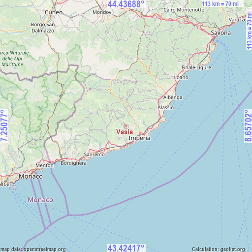
Vasia GPS coordinates[2]
43° 55' 57.648" North, 7° 57' 14.004" East
| Map corner | latitude | longitude |
|---|---|---|
| Upper-left | 44.43688°, | 7.25077° |
| Center: | 43.93268°, | 7.95389° |
| Lower-right: | 43.42417°, | 8.65702° |
| Map W x H: | 112.6×112.6 km | = 70×70mi |
| max Lat: | 47.04031° ⇑55.4% North |
| Vasia: | 43.93268° |
| min Lat: | ⇓44.6% South 35.50142° |
| min Long | Vasia | max Long |
| 6.69888° | 7.95389° | 18.48682° |
| W 5.9%⇐ | ⇒94.1% E |
Elevation
Elevation of Vasia is 367 m = 1204 ft, and this is 60.3 m = 198 ft above average elevation for this country.
| Max E: |
2085 m = 6841 ft | 32.6% |
| Vasia | 367 m 1204 ft | |
| Avg. | 306.7 m = 1006 ft | |
Min E: |
-4 m = -13 ft | 67.4% |
See also: Italy elevation on elevation.city.
Geographical zone
Vasia is located in North temperate zone (between Tropic of Cancer and the Arctic Circle). Distance of this Northern Tropic circle is 2278.9 km =1416 mi to South.| Distance of | km | miles | from Vasia |
|---|---|---|---|
| North Pole | 5122.2 | 3182.8 | to North |
| Arctic Circle | 2516.3 | 1563.6 | to North |
| Tropic Cancer | 2278.9 | 1416 | to South |
| Equator | 4884.9 | 3035.3 | to South |


Nearby cities:
15 places around Vasia: (largest is in red/bold)
• Aurigo
6.1 km =3.8 mi,  336°
336°
• Borgo Sant'Agata
5.5 km =3.4 mi,  126°
126°
• Borgomaro
4.8 km =3 mi,  350°
350°
• Caravonica
6.7 km =4.2 mi,  2°
2°
• Chiusanico
5.4 km =3.4 mi,  34°
34°
• Chiusavecchia
4.6 km =2.9 mi, 32°
• Civezza
5.9 km =3.7 mi,  181°
181°
• Diano Arentino
7.3 km =4.5 mi,  74°
74°
• Dolcedo
2.8 km =1.7 mi,  187°
187°
• Lucinasco
3.7 km =2.3 mi,  7°
7°
• Molini
1.5 km =0.9 mi,  238°
238°
• Pietrabruna
6.3 km =3.9 mi,  220°
220°
• Poggi Inferiore Poggi Superiore
7.3 km =4.5 mi,  160°
160°
• Pontedassio
4.9 km =3 mi,  82°
82°
• Prelà Castello
1.1 km =0.7 mi,  316°
316°
Sources, notices
• [Note1] Compared only with cities in Italy existing in our database
• [Src1] Map data: © OpenStreetMap contributors (CC-BY-SA)
• [Src2] Other city data from geonames.org with taken over terms of usage.
• [Src3] Geographical zone / Annual Mean Temperature by Robert A. Rohde @ Wikipedia
