Dolcedo geodata
Dolcedo (Liguria) is a seat of a third-order administrative division; located in Italy in Europe/Rome (GMT+2) time zone. With population of 646 people, there are 8661 cities with bigger population in this country. Compared to other cities in Italy, 55.6% of cities are located further ↑North; 94.2% of cities are located further →East and 71.1% of cities have higher elevation than Dolcedo. Note1


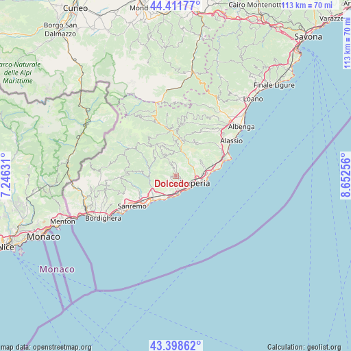
Dolcedo GPS coordinates[2]
43° 54' 26.46" North, 7° 56' 57.948" East
| Map corner | latitude | longitude |
|---|---|---|
| Upper-left | 44.41177°, | 7.24631° |
| Center: | 43.90735°, | 7.94943° |
| Lower-right: | 43.39862°, | 8.65256° |
| Map W x H: | 112.7×112.7 km | = 70×70mi |
| max Lat: | 47.04031° ⇑55.6% North |
| Dolcedo: | 43.90735° |
| min Lat: | ⇓44.4% South 35.50142° |
| min Long | Dolcedo | max Long |
| 6.69888° | 7.94943° | 18.48682° |
| W 5.8%⇐ | ⇒94.2% E |
Elevation
Elevation of Dolcedo is 92 m = 302 ft, and this is 214.7 m = 704 ft below average elevation for this country.
| Max E: |
2085 m = 6841 ft | 71.1% |
| Avg. | 306.7 m = 1006 ft | |
| Dolcedo | 92 m = 302 ft | |
Min E: |
-4 m = -13 ft | 28.9% |
See also: Italy elevation on elevation.city.
Geographical zone
Dolcedo is located in North temperate zone (between Tropic of Cancer and the Arctic Circle). Distance of this Northern Tropic circle is 2276.1 km =1414.3 mi to South.| Distance of | km | miles | from Dolcedo |
|---|---|---|---|
| North Pole | 5125 | 3184.5 | to North |
| Arctic Circle | 2519.1 | 1565.3 | to North |
| Tropic Cancer | 2276.1 | 1414.3 | to South |
| Equator | 4882 | 3033.5 | to South |


Nearby cities:
15 places around Dolcedo: (largest is in red/bold)
• Borgo Sant'Agata
4.8 km =3 mi,  95°
95°
• Chiusavecchia
7.2 km =4.5 mi,  22°
22°
• Cipressa
6.3 km =3.9 mi,  193°
193°
• Civezza
3.1 km =1.9 mi,  176°
176°
• Costarainera
5.9 km =3.7 mi, 186°
• Imperia
7.5 km =4.7 mi,  105°
105°
• Lucinasco
6.6 km =4.1 mi,  7°
7°
• Molini
2.2 km =1.4 mi,  336°
336°
• Pietrabruna
4.2 km =2.6 mi,  241°
241°
• Poggi Inferiore Poggi Superiore
5 km =3.1 mi,  146°
146°
• Pontedassio
6.3 km =3.9 mi,  56°
56°
• Prelà Castello
3.7 km =2.3 mi,  353°
353°
• San Lorenzo al Mare
6.1 km =3.8 mi,  168°
168°
• Terzorio
7.4 km =4.6 mi,  213°
213°
• Vasia
2.8 km =1.7 mi, 7°
Sources, notices
• [Note1] Compared only with cities in Italy existing in our database
• [Src1] Map data: © OpenStreetMap contributors (CC-BY-SA)
• [Src2] Other city data from geonames.org with taken over terms of usage.
• [Src3] Geographical zone / Annual Mean Temperature by Robert A. Rohde @ Wikipedia
