Salizzole geodata
Salizzole (Veneto) is a seat of a third-order administrative division; located in Italy in Europe/Rome (GMT+2) time zone. With population of 1,653 people, there are 4776 cities with bigger population in this country. Compared to other cities in Italy, 65.9% of cities are located further ↓South; 56% of cities are located further →East and 89% of cities have higher elevation than Salizzole. Note1


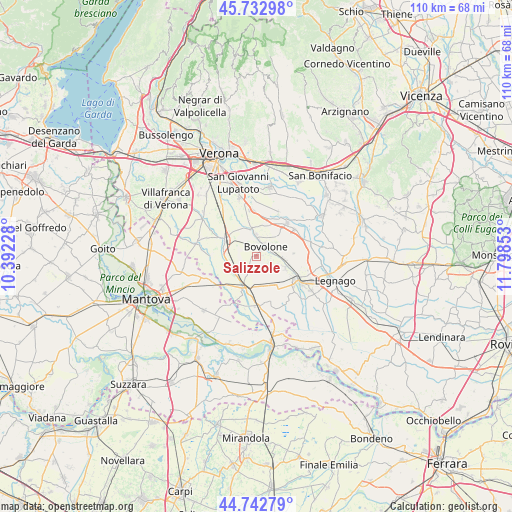
Salizzole GPS coordinates[2]
45° 14' 24.144" North, 11° 5' 43.44" East
| Map corner | latitude | longitude |
|---|---|---|
| Upper-left | 45.73298°, | 10.39228° |
| Center: | 45.24004°, | 11.0954° |
| Lower-right: | 44.74279°, | 11.79853° |
| Map W x H: | 110.1×110.1 km | = 68.4×68.4mi |
| max Lat: | 47.04031° ⇑34.1% North |
| Salizzole: | 45.24004° |
| min Lat: | ⇓65.9% South 35.50142° |
| min Long | Salizzole | max Long |
| 6.69888° | 11.0954° | 18.48682° |
| W 44%⇐ | ⇒56% E |
Elevation
Elevation of Salizzole is 20 m = 66 ft, and this is 286.7 m = 941 ft below average elevation for this country.
| Max E: |
2085 m = 6841 ft | 89% |
| Avg. | 306.7 m = 1006 ft | |
| Salizzole | 20 m = 66 ft | |
Min E: |
-4 m = -13 ft | 11% |
See also: Italy elevation on elevation.city.
Geographical zone
Salizzole is located in North temperate zone (between Tropic of Cancer and the Arctic Circle). Distance of this North polar circle is 2371 km =1473.3 mi to North.| Distance of | km | miles | from Salizzole |
|---|---|---|---|
| North Pole | 4976.8 | 3092.4 | to North |
| Arctic Circle | 2371 | 1473.3 | to North |
| Tropic Cancer | 2424.3 | 1506.4 | to South |
| Equator | 5030.2 | 3125.6 | to South |


Nearby cities:
15 places around Salizzole: (largest is in red/bold)
• Asparetto
7.2 km =4.5 mi,  108°
108°
• Bionde
4.5 km =2.8 mi,  175°
175°
• Bonavicina
7 km =4.3 mi,  86°
86°
• Bonferraro
9 km =5.6 mi,  226°
226°
• Bovolone
3 km =1.9 mi,  36°
36°
• Ca' degli Oppi
6.7 km =4.2 mi,  23°
23°
• Capitello
5 km =3.1 mi,  135°
135°
• Isola della Scala
7.6 km =4.7 mi,  295°
295°
• Nogara
7.1 km =4.4 mi,  202°
202°
• Pellegrina
6.1 km =3.8 mi,  257°
257°
• Piazza
4.6 km =2.9 mi,  126°
126°
• Sanguinetto
7.1 km =4.4 mi,  147°
147°
• Sorgà
9.5 km =5.9 mi,  251°
251°
• Tarmassia
4.6 km =2.9 mi,  317°
317°
• Villafontana
5.9 km =3.7 mi,  352°
352°
Sources, notices
• [Note1] Compared only with cities in Italy existing in our database
• [Src1] Map data: © OpenStreetMap contributors (CC-BY-SA)
• [Src2] Other city data from geonames.org with taken over terms of usage.
• [Src3] Geographical zone / Annual Mean Temperature by Robert A. Rohde @ Wikipedia
