Tarmassia geodata
Tarmassia (Veneto) is a populated place; located in Italy in Europe/Rome (GMT+2) time zone. With population of 747 people, there are 7973 cities with bigger population in this country. Compared to other cities in Italy, 66.7% of cities are located further ↓South; 56.5% of cities are located further →East and 86.1% of cities have higher elevation than Tarmassia. Note1


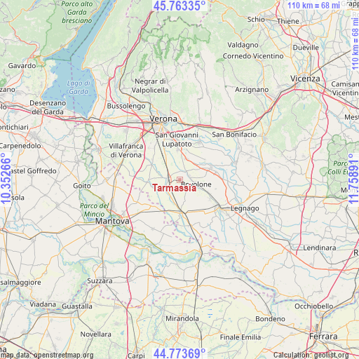
Tarmassia GPS coordinates[2]
45° 16' 14.448" North, 11° 3' 20.808" East
| Map corner | latitude | longitude |
|---|---|---|
| Upper-left | 45.76335°, | 10.35266° |
| Center: | 45.27068°, | 11.05578° |
| Lower-right: | 44.77369°, | 11.75891° |
| Map W x H: | 110×110 km | = 68.4×68.4mi |
| max Lat: | 47.04031° ⇑33.3% North |
| Tarmassia: | 45.27068° |
| min Lat: | ⇓66.7% South 35.50142° |
| min Long | Tarmassia | max Long |
| 6.69888° | 11.05578° | 18.48682° |
| W 43.5%⇐ | ⇒56.5% E |
Elevation
Elevation of Tarmassia is 28 m = 92 ft, and this is 278.7 m = 914 ft below average elevation for this country.
| Max E: |
2085 m = 6841 ft | 86.1% |
| Avg. | 306.7 m = 1006 ft | |
| Tarmassia | 28 m = 92 ft | |
Min E: |
-4 m = -13 ft | 13.9% |
See also: Italy elevation on elevation.city.
Geographical zone
Tarmassia is located in North temperate zone (between Tropic of Cancer and the Arctic Circle). Distance of this North polar circle is 2367.5 km =1471.1 mi to North.| Distance of | km | miles | from Tarmassia |
|---|---|---|---|
| North Pole | 4973.4 | 3090.3 | to North |
| Arctic Circle | 2367.5 | 1471.1 | to North |
| Tropic Cancer | 2427.7 | 1508.5 | to South |
| Equator | 5033.6 | 3127.7 | to South |


Nearby cities:
15 places around Tarmassia: (largest is in red/bold)
• Bionde
8.6 km =5.3 mi,  156°
156°
• Bovolone
5 km =3.1 mi,  101°
101°
• Buttapietra
9 km =5.6 mi,  330°
330°
• Ca' degli Oppi
6.4 km =4 mi,  64°
64°
• Capitello
9.6 km =6 mi,  136°
136°
• Erbè
7.3 km =4.5 mi,  244°
244°
• Isola della Scala
3.7 km =2.3 mi,  267°
267°
• Pellegrina
5.5 km =3.4 mi,  211°
211°
• Piazza
9.1 km =5.7 mi,  131°
131°
• Raldon
8.8 km =5.5 mi,  350°
350°
• Salizzole
4.6 km =2.9 mi, 137°
• Sorgà
8.7 km =5.4 mi,  222°
222°
• Trevenzuolo
9.5 km =5.9 mi, 269°
• Vallese
6.8 km =4.2 mi,  20°
20°
• Villafontana
3.4 km =2.1 mi,  42°
42°
Sources, notices
• [Note1] Compared only with cities in Italy existing in our database
• [Src1] Map data: © OpenStreetMap contributors (CC-BY-SA)
• [Src2] Other city data from geonames.org with taken over terms of usage.
• [Src3] Geographical zone / Annual Mean Temperature by Robert A. Rohde @ Wikipedia
