Gussola geodata
Gussola (Lombardy) is a seat of a third-order administrative division; located in Italy in Europe/Rome (GMT+2) time zone. With population of 2,789 people, there are 3225 cities with bigger population in this country. Compared to other cities in Italy, 60.2% of cities are located further ↓South; 64.5% of cities are located further →East and 86.4% of cities have higher elevation than Gussola. Note1


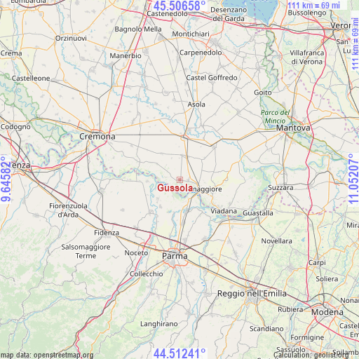
Gussola GPS coordinates[2]
45° 0' 41.94" North, 10° 20' 56.184" East
| Map corner | latitude | longitude |
|---|---|---|
| Upper-left | 45.50658°, | 9.64582° |
| Center: | 45.01165°, | 10.34894° |
| Lower-right: | 44.51241°, | 11.05207° |
| Map W x H: | 110.5×110.5 km | = 68.7×68.7mi |
| max Lat: | 47.04031° ⇑39.8% North |
| Gussola: | 45.01165° |
| min Lat: | ⇓60.2% South 35.50142° |
| min Long | Gussola | max Long |
| 6.69888° | 10.34894° | 18.48682° |
| W 35.5%⇐ | ⇒64.5% E |
Elevation
Elevation of Gussola is 27 m = 89 ft, and this is 279.7 m = 918 ft below average elevation for this country.
| Max E: |
2085 m = 6841 ft | 86.4% |
| Avg. | 306.7 m = 1006 ft | |
| Gussola | 27 m = 89 ft | |
Min E: |
-4 m = -13 ft | 13.6% |
See also: Italy elevation on elevation.city.
Geographical zone
Gussola is located in North temperate zone (between Tropic of Cancer and the Arctic Circle). Distance of this North polar circle is 2396.3 km =1489 mi to North.| Distance of | km | miles | from Gussola |
|---|---|---|---|
| North Pole | 5002.2 | 3108.2 | to North |
| Arctic Circle | 2396.3 | 1489 | to North |
| Tropic Cancer | 2398.9 | 1490.6 | to South |
| Equator | 5004.8 | 3109.8 | to South |


Nearby cities:
15 places around Gussola: (largest is in red/bold)
• Casalmaggiore
6.1 km =3.8 mi,  113°
113°
• Casteldidone
7.9 km =4.9 mi,  34°
34°
• Colorno
9.7 km =6 mi,  168°
168°
• Coltaro
5.5 km =3.4 mi,  203°
203°
• Martignana di Po
2.4 km =1.5 mi,  91°
91°
• Motta Baluffi
8.6 km =5.3 mi,  304°
304°
• Ponteterra
9.3 km =5.8 mi,  101°
101°
• Rivarolo Mantovano
9.7 km =6 mi,  45°
45°
• San Giovanni in Croce
7.2 km =4.5 mi,  15°
15°
• San Martino del Lago
7.2 km =4.5 mi,  338°
338°
• Scandolara Ravara
5.9 km =3.7 mi,  321°
321°
• Sissa
9.1 km =5.7 mi,  230°
230°
• Solarolo Rainerio
7.8 km =4.8 mi,  4°
4°
• Torricella del Pizzo
4.3 km =2.7 mi,  282°
282°
• Vicomoscano
9 km =5.6 mi,  117°
117°
Sources, notices
• [Note1] Compared only with cities in Italy existing in our database
• [Src1] Map data: © OpenStreetMap contributors (CC-BY-SA)
• [Src2] Other city data from geonames.org with taken over terms of usage.
• [Src3] Geographical zone / Annual Mean Temperature by Robert A. Rohde @ Wikipedia
