Casteldidone geodata
Casteldidone (Lombardy) is a seat of a third-order administrative division; located in Italy in Europe/Rome (GMT+2) time zone. With population of 532 people, there are 9625 cities with bigger population in this country. Compared to other cities in Italy, 61.8% of cities are located further ↓South; 63.9% of cities are located further →East and 86.1% of cities have higher elevation than Casteldidone. Note1


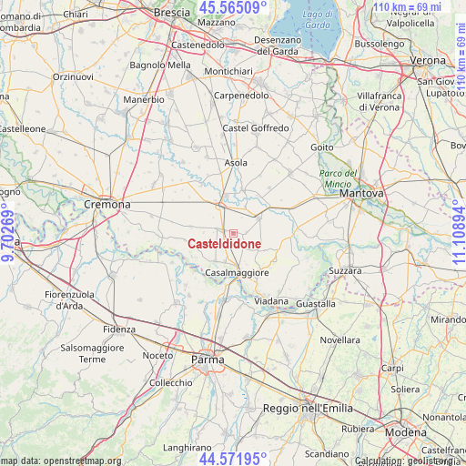
Casteldidone GPS coordinates[2]
45° 4' 14.448" North, 10° 24' 20.916" East
| Map corner | latitude | longitude |
|---|---|---|
| Upper-left | 45.56509°, | 9.70269° |
| Center: | 45.07068°, | 10.40581° |
| Lower-right: | 44.57195°, | 11.10894° |
| Map W x H: | 110.4×110.4 km | = 68.6×68.6mi |
| max Lat: | 47.04031° ⇑38.2% North |
| Casteldidone: | 45.07068° |
| min Lat: | ⇓61.8% South 35.50142° |
| min Long | Casteldidone | max Long |
| 6.69888° | 10.40581° | 18.48682° |
| W 36.1%⇐ | ⇒63.9% E |
Elevation
Elevation of Casteldidone is 28 m = 92 ft, and this is 278.7 m = 914 ft below average elevation for this country.
| Max E: |
2085 m = 6841 ft | 86.1% |
| Avg. | 306.7 m = 1006 ft | |
| Casteldidone | 28 m = 92 ft | |
Min E: |
-4 m = -13 ft | 13.9% |
See also: Italy elevation on elevation.city.
Geographical zone
Casteldidone is located in North temperate zone (between Tropic of Cancer and the Arctic Circle). Distance of this North polar circle is 2389.8 km =1485 mi to North.| Distance of | km | miles | from Casteldidone |
|---|---|---|---|
| North Pole | 4995.7 | 3104.2 | to North |
| Arctic Circle | 2389.8 | 1485 | to North |
| Tropic Cancer | 2405.5 | 1494.7 | to South |
| Equator | 5011.4 | 3113.9 | to South |


Nearby cities:
15 places around Casteldidone: (largest is in red/bold)
• Bozzolo
6.8 km =4.2 mi,  58°
58°
• Calvatone
6.8 km =4.2 mi,  23°
23°
• Casalmaggiore
9.1 km =5.7 mi,  172°
172°
• Gussola
7.9 km =4.9 mi,  214°
214°
• Martignana di Po
6.9 km =4.3 mi,  197°
197°
• Piadena
7 km =4.3 mi,  337°
337°
• Rivarolo Mantovano
2.5 km =1.6 mi,  84°
84°
• Rivarolo del Re
6.8 km =4.2 mi,  129°
129°
• San Giovanni in Croce
2.6 km =1.6 mi,  278°
278°
• San Martino del Lago
7.1 km =4.4 mi,  271°
271°
• Scandolara Ravara
8.4 km =5.2 mi,  256°
256°
• Solarolo Rainerio
4 km =2.5 mi,  287°
287°
• Spineda
8.4 km =5.2 mi,  97°
97°
• Tornata
4.2 km =2.6 mi,  27°
27°
• Voltido
7.3 km =4.5 mi,  308°
308°
Sources, notices
• [Note1] Compared only with cities in Italy existing in our database
• [Src1] Map data: © OpenStreetMap contributors (CC-BY-SA)
• [Src2] Other city data from geonames.org with taken over terms of usage.
• [Src3] Geographical zone / Annual Mean Temperature by Robert A. Rohde @ Wikipedia
