Coltaro geodata
Coltaro (Emilia-Romagna) is a populated place; located in Italy in Europe/Rome (GMT+2) time zone. With population of 841 people, there are 7442 cities with bigger population in this country. Compared to other cities in Italy, 59.2% of cities are located further ↓South; 64.8% of cities are located further →East and 85.6% of cities have higher elevation than Coltaro. Note1
Administrative division(s):
- Level 1: Emilia-Romagna
- Level 2: Provincia di Parma
- Level 3: Sissa Trecasali


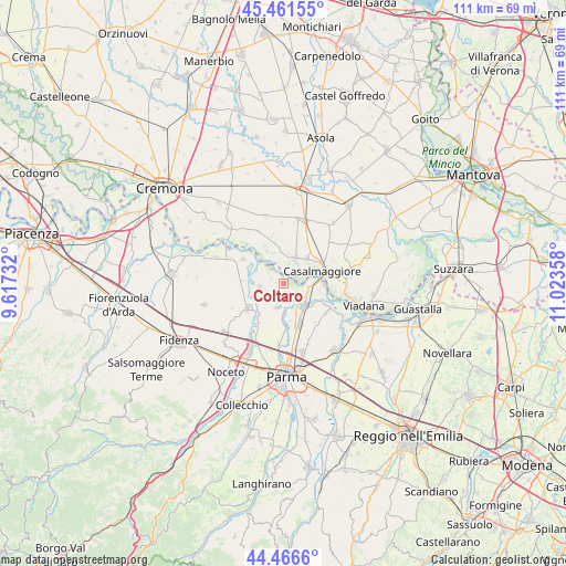
Coltaro GPS coordinates[2]
44° 57' 58.428" North, 10° 19' 13.62" East
| Map corner | latitude | longitude |
|---|---|---|
| Upper-left | 45.46155°, | 9.61732° |
| Center: | 44.96623°, | 10.32045° |
| Lower-right: | 44.4666°, | 11.02358° |
| Map W x H: | 110.6×110.6 km | = 68.7×68.7mi |
| max Lat: | 47.04031° ⇑40.8% North |
| Coltaro: | 44.96623° |
| min Lat: | ⇓59.2% South 35.50142° |
| min Long | Coltaro | max Long |
| 6.69888° | 10.32045° | 18.48682° |
| W 35.2%⇐ | ⇒64.8% E |
Elevation
Elevation of Coltaro is 29 m = 95 ft, and this is 277.7 m = 911 ft below average elevation for this country.
| Max E: |
2085 m = 6841 ft | 85.6% |
| Avg. | 306.7 m = 1006 ft | |
| Coltaro | 29 m = 95 ft | |
Min E: |
-4 m = -13 ft | 14.4% |
See also: Italy elevation on elevation.city.
Geographical zone
Coltaro is located in North temperate zone (between Tropic of Cancer and the Arctic Circle). Distance of this Northern Tropic circle is 2393.9 km =1487.5 mi to South.| Distance of | km | miles | from Coltaro |
|---|---|---|---|
| North Pole | 5007.3 | 3111.4 | to North |
| Arctic Circle | 2401.4 | 1492.2 | to North |
| Tropic Cancer | 2393.9 | 1487.5 | to South |
| Equator | 4999.8 | 3106.7 | to South |


Nearby cities:
15 places around Coltaro: (largest is in red/bold)
• Casalmaggiore
8.3 km =5.2 mi,  71°
71°
• Colorno
6.1 km =3.8 mi,  137°
137°
• Fontanelle
8.3 km =5.2 mi,  272°
272°
• Gussola
5.5 km =3.4 mi,  23°
23°
• Martignana di Po
6.8 km =4.2 mi,  43°
43°
• Mezzano Superiore
9 km =5.6 mi,  114°
114°
• Rivarolo
6.9 km =4.3 mi,  182°
182°
• Roccabianca
9.3 km =5.8 mi,  299°
299°
• Ronco Campo Canneto
8.3 km =5.2 mi,  215°
215°
• San Polo
9 km =5.6 mi,  161°
161°
• San Secondo Parmense
8.6 km =5.3 mi,  235°
235°
• Sissa
4.8 km =3 mi,  260°
260°
• Torricella del Pizzo
6.3 km =3.9 mi,  341°
341°
• Torrile
4.6 km =2.9 mi, 176°
• Trecasali
4.9 km =3 mi,  229°
229°
Sources, notices
• [Note1] Compared only with cities in Italy existing in our database
• [Src1] Map data: © OpenStreetMap contributors (CC-BY-SA)
• [Src2] Other city data from geonames.org with taken over terms of usage.
• [Src3] Geographical zone / Annual Mean Temperature by Robert A. Rohde @ Wikipedia
