Sissa geodata
Sissa (Emilia-Romagna) is a seat of a third-order administrative division; located in Italy in Europe/Rome (GMT+2) time zone. With population of 1,805 people, there are 4479 cities with bigger population in this country. Compared to other cities in Italy, 59.1% of cities are located further ↓South; 65.5% of cities are located further →East and 85% of cities have higher elevation than Sissa. Note1
Administrative division(s):
- Level 1: Emilia-Romagna
- Level 2: Provincia di Parma
- Level 3: Sissa Trecasali


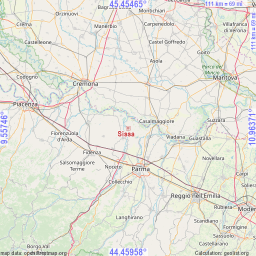
Sissa GPS coordinates[2]
44° 57' 33.372" North, 10° 15' 38.088" East
| Map corner | latitude | longitude |
|---|---|---|
| Upper-left | 45.45465°, | 9.55746° |
| Center: | 44.95927°, | 10.26058° |
| Lower-right: | 44.45958°, | 10.96371° |
| Map W x H: | 110.6×110.6 km | = 68.7×68.7mi |
| max Lat: | 47.04031° ⇑40.9% North |
| Sissa: | 44.95927° |
| min Lat: | ⇓59.1% South 35.50142° |
| min Long | Sissa | max Long |
| 6.69888° | 10.26058° | 18.48682° |
| W 34.5%⇐ | ⇒65.5% E |
Elevation
Elevation of Sissa is 31 m = 102 ft, and this is 275.7 m = 905 ft below average elevation for this country.
| Max E: |
2085 m = 6841 ft | 85% |
| Avg. | 306.7 m = 1006 ft | |
| Sissa | 31 m = 102 ft | |
Min E: |
-4 m = -13 ft | 15% |
See also: Italy elevation on elevation.city.
Geographical zone
Sissa is located in North temperate zone (between Tropic of Cancer and the Arctic Circle). Distance of this Northern Tropic circle is 2393.1 km =1487 mi to South.| Distance of | km | miles | from Sissa |
|---|---|---|---|
| North Pole | 5008.1 | 3111.9 | to North |
| Arctic Circle | 2402.2 | 1492.7 | to North |
| Tropic Cancer | 2393.1 | 1487 | to South |
| Equator | 4999 | 3106.2 | to South |


Nearby cities:
15 places around Sissa: (largest is in red/bold)
• Colorno
9.6 km =6 mi,  112°
112°
• Coltaro
4.8 km =3 mi,  80°
80°
• Fontanelle
3.8 km =2.4 mi,  287°
287°
• Gussola
9.1 km =5.7 mi,  50°
50°
• Motta Baluffi
10.7 km =6.6 mi,  359°
359°
• Pieveottoville
10.2 km =6.3 mi,  305°
305°
• Rivarolo
7.5 km =4.7 mi,  144°
144°
• Roccabianca
6.3 km =3.9 mi,  328°
328°
• Ronco Campo Canneto
6 km =3.7 mi,  180°
180°
• San Polo
10.8 km =6.7 mi, 135°
• San Secondo Parmense
4.8 km =3 mi,  209°
209°
• Scandolara Ravara
10.9 km =6.8 mi,  17°
17°
• Torricella del Pizzo
7.3 km =4.5 mi, 21°
• Torrile
6.3 km =3.9 mi,  127°
127°
• Trecasali
2.6 km =1.6 mi,  158°
158°
Sources, notices
• [Note1] Compared only with cities in Italy existing in our database
• [Src1] Map data: © OpenStreetMap contributors (CC-BY-SA)
• [Src2] Other city data from geonames.org with taken over terms of usage.
• [Src3] Geographical zone / Annual Mean Temperature by Robert A. Rohde @ Wikipedia
