Grutti geodata
Grutti (Umbria) is a populated place; located in Italy in Europe/Rome (GMT+2) time zone. With population of 599 people, there are 9016 cities with bigger population in this country. Compared to other cities in Italy, 64.4% of cities are located further ↑North; 62.1% of cities are located further ←West and 79.1% of cities have lower elevation than Grutti. Note1


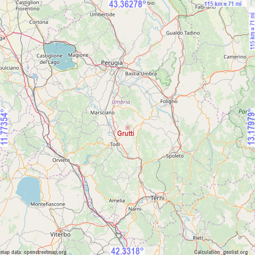
Grutti GPS coordinates[2]
42° 50' 57.984" North, 12° 28' 35.976" East
| Map corner | latitude | longitude |
|---|---|---|
| Upper-left | 43.36278°, | 11.77354° |
| Center: | 42.84944°, | 12.47666° |
| Lower-right: | 42.3318°, | 13.17979° |
| Map W x H: | 114.6×114.6 km | = 71.2×71.2mi |
| max Lat: | 47.04031° ⇑64.4% North |
| Grutti: | 42.84944° |
| min Lat: | ⇓35.6% South 35.50142° |
| min Long | Grutti | max Long |
| 6.69888° | 12.47666° | 18.48682° |
| W 62.1%⇐ | ⇒37.9% E |
Elevation
Elevation of Grutti is 508 m = 1667 ft, and this is 201.3 m = 660 ft above average elevation for this country.
| Max E: |
2085 m = 6841 ft | 20.9% |
| Grutti | 508 m 1667 ft | |
| Avg. | 306.7 m = 1006 ft | |
Min E: |
-4 m = -13 ft | 79.1% |
See also: Italy elevation on elevation.city.
Geographical zone
Grutti is located in North temperate zone (between Tropic of Cancer and the Arctic Circle). Distance of this Northern Tropic circle is 2158.5 km =1341.2 mi to South.| Distance of | km | miles | from Grutti |
|---|---|---|---|
| North Pole | 5242.7 | 3257.7 | to North |
| Arctic Circle | 2636.8 | 1638.4 | to North |
| Tropic Cancer | 2158.5 | 1341.2 | to South |
| Equator | 4764.4 | 2960.5 | to South |


Nearby cities:
15 places around Grutti: (largest is in red/bold)
• Bastardo
7.2 km =4.5 mi,  70°
70°
• Collazzone
6.7 km =4.2 mi,  330°
330°
• Collepepe
9.9 km =6.2 mi,  317°
317°
• Colvalenza
11.4 km =7.1 mi,  179°
179°
• Fratta Todina
9.2 km =5.7 mi,  275°
275°
• Giano dell'Umbria
8.4 km =5.2 mi,  101°
101°
• Gualdo Cattaneo
9.6 km =6 mi,  43°
43°
• Marcellano
4.2 km =2.6 mi,  49°
49°
• Massa Martana
9.4 km =5.8 mi,  154°
154°
• Monte Castello di Vibio
10.2 km =6.3 mi,  264°
264°
• Pantalla
6.9 km =4.3 mi,  292°
292°
• Ponterio-Pian di Porto
7.1 km =4.4 mi,  229°
229°
• Ripabianca
11.7 km =7.3 mi, 329°
• San Terenziano
2 km =1.2 mi,  351°
351°
• Todi
9.5 km =5.9 mi,  213°
213°
Sources, notices
• [Note1] Compared only with cities in Italy existing in our database
• [Src1] Map data: © OpenStreetMap contributors (CC-BY-SA)
• [Src2] Other city data from geonames.org with taken over terms of usage.
• [Src3] Geographical zone / Annual Mean Temperature by Robert A. Rohde @ Wikipedia
