Collepepe geodata
Collepepe (Umbria) is a populated place; located in Italy in Europe/Rome (GMT+2) time zone. With population of 1,347 people, there are 5493 cities with bigger population in this country. Compared to other cities in Italy, 63.9% of cities are located further ↑North; 61.2% of cities are located further ←West and 56.8% of cities have higher elevation than Collepepe. Note1


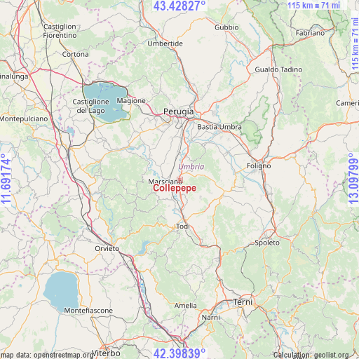
Collepepe GPS coordinates[2]
42° 54' 55.728" North, 12° 23' 41.496" East
| Map corner | latitude | longitude |
|---|---|---|
| Upper-left | 43.42827°, | 11.69174° |
| Center: | 42.91548°, | 12.39486° |
| Lower-right: | 42.39839°, | 13.09799° |
| Map W x H: | 114.5×114.5 km | = 71.1×71.1mi |
| max Lat: | 47.04031° ⇑63.9% North |
| Collepepe: | 42.91548° |
| min Lat: | ⇓36.1% South 35.50142° |
| min Long | Collepepe | max Long |
| 6.69888° | 12.39486° | 18.48682° |
| W 61.2%⇐ | ⇒38.8% E |
Elevation
Elevation of Collepepe is 189 m = 620 ft, and this is 117.7 m = 386 ft below average elevation for this country.
| Max E: |
2085 m = 6841 ft | 56.8% |
| Avg. | 306.7 m = 1006 ft | |
| Collepepe | 189 m = 620 ft | |
Min E: |
-4 m = -13 ft | 43.2% |
See also: Italy elevation on elevation.city.
Geographical zone
Collepepe is located in North temperate zone (between Tropic of Cancer and the Arctic Circle). Distance of this Northern Tropic circle is 2165.8 km =1345.8 mi to South.| Distance of | km | miles | from Collepepe |
|---|---|---|---|
| North Pole | 5235.3 | 3253.1 | to North |
| Arctic Circle | 2629.4 | 1633.8 | to North |
| Tropic Cancer | 2165.8 | 1345.8 | to South |
| Equator | 4771.8 | 2965.1 | to South |


Nearby cities:
15 places around Collepepe: (largest is in red/bold)
• Cerqueto
7.4 km =4.6 mi,  303°
303°
• Collazzone
3.7 km =2.3 mi,  115°
115°
• Deruta
7.9 km =4.9 mi,  13°
13°
• Fratta Todina
7 km =4.3 mi,  201°
201°
• Grutti
9.9 km =6.2 mi,  137°
137°
• Marcellano
10.9 km =6.8 mi, 115°
• Marsciano
3.6 km =2.2 mi,  279°
279°
• Monte Castello di Vibio
9 km =5.6 mi, 202°
• Pantalla
4.7 km =2.9 mi,  176°
176°
• Ponte Nuovo
10.3 km =6.4 mi,  15°
15°
• Ripabianca
2.8 km =1.7 mi, 14°
• San Niccolò di Celle
11.3 km =7 mi,  355°
355°
• San Terenziano
8.3 km =5.2 mi,  130°
130°
• Sant'Angelo di Celle
9.2 km =5.7 mi,  354°
354°
• Sant'Enea
10.9 km =6.8 mi,  343°
343°
Sources, notices
• [Note1] Compared only with cities in Italy existing in our database
• [Src1] Map data: © OpenStreetMap contributors (CC-BY-SA)
• [Src2] Other city data from geonames.org with taken over terms of usage.
• [Src3] Geographical zone / Annual Mean Temperature by Robert A. Rohde @ Wikipedia
