Cortenuova geodata
Cortenuova (Lombardy) is a seat of a third-order administrative division; located in Italy in Europe/Rome (GMT+2) time zone. With population of 1,367 people, there are 5450 cities with bigger population in this country. Compared to other cities in Italy, 74.9% of cities are located further ↓South; 69.9% of cities are located further →East and 64% of cities have higher elevation than Cortenuova. Note1


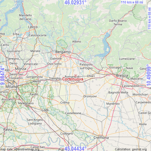
Cortenuova GPS coordinates[2]
45° 32' 20.328" North, 9° 47' 16.296" East
| Map corner | latitude | longitude |
|---|---|---|
| Upper-left | 46.02931°, | 9.08474° |
| Center: | 45.53898°, | 9.78786° |
| Lower-right: | 45.04434°, | 10.49099° |
| Map W x H: | 109.5×109.5 km | = 68×68mi |
| max Lat: | 47.04031° ⇑25.1% North |
| Cortenuova: | 45.53898° |
| min Lat: | ⇓74.9% South 35.50142° |
| min Long | Cortenuova | max Long |
| 6.69888° | 9.78786° | 18.48682° |
| W 30.1%⇐ | ⇒69.9% E |
Elevation
Elevation of Cortenuova is 134 m = 440 ft, and this is 172.7 m = 567 ft below average elevation for this country.
| Max E: |
2085 m = 6841 ft | 64% |
| Avg. | 306.7 m = 1006 ft | |
| Cortenuova | 134 m = 440 ft | |
Min E: |
-4 m = -13 ft | 36% |
See also: Italy elevation on elevation.city.
Geographical zone
Cortenuova is located in North temperate zone (between Tropic of Cancer and the Arctic Circle). Distance of this North polar circle is 2337.7 km =1452.6 mi to North.| Distance of | km | miles | from Cortenuova |
|---|---|---|---|
| North Pole | 4943.6 | 3071.8 | to North |
| Arctic Circle | 2337.7 | 1452.6 | to North |
| Tropic Cancer | 2457.5 | 1527 | to South |
| Equator | 5063.5 | 3146.3 | to South |


Nearby cities:
15 places around Cortenuova: (largest is in red/bold)
• Antegnate
5.8 km =3.6 mi,  177°
177°
• Barbata
7.2 km =4.5 mi,  186°
186°
• Calcio
5.9 km =3.7 mi,  125°
125°
• Cividate al Piano
3.7 km =2.3 mi,  62°
62°
• Cortenuova di Sopra
0.8 km =0.5 mi,  313°
313°
• Covo
4.6 km =2.9 mi,  196°
196°
• Fara Olivana
5.7 km =3.5 mi,  211°
211°
• Ghisalba
6.5 km =4 mi,  338°
338°
• Martinengo
4 km =2.5 mi, 336°
• Morengo
6.4 km =4 mi,  262°
262°
• Mornico al Serio
6.1 km =3.8 mi,  15°
15°
• Palosco
6.8 km =4.2 mi,  34°
34°
• Pontoglio
6.1 km =3.8 mi, 56°
• Romano di Lombardia
3.3 km =2.1 mi,  232°
232°
• Urago d'Oglio
6.9 km =4.3 mi,  111°
111°
Sources, notices
• [Note1] Compared only with cities in Italy existing in our database
• [Src1] Map data: © OpenStreetMap contributors (CC-BY-SA)
• [Src2] Other city data from geonames.org with taken over terms of usage.
• [Src3] Geographical zone / Annual Mean Temperature by Robert A. Rohde @ Wikipedia
