Garadassi geodata
Garadassi (Piedmont) is a seat of a third-order administrative division; located in Italy in Europe/Rome (GMT+2) time zone. With population of 29 people, there are 11651 cities with bigger population in this country. Compared to other cities in Italy, 55.3% of cities are located further ↓South; 78.8% of cities are located further →East and 89.7% of cities have lower elevation than Garadassi. Note1
Administrative division(s):
- Level 1: Piedmont
- Level 2: Provincia di Alessandria
- Level 3: Fabbrica Curone


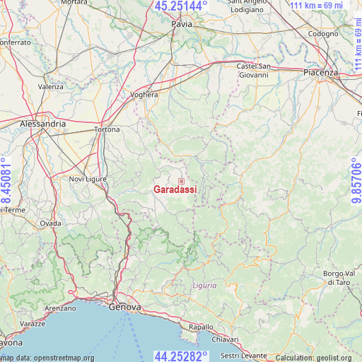
Garadassi GPS coordinates[2]
44° 45' 15.444" North, 9° 9' 14.148" East
| Map corner | latitude | longitude |
|---|---|---|
| Upper-left | 45.25144°, | 8.45081° |
| Center: | 44.75429°, | 9.15393° |
| Lower-right: | 44.25282°, | 9.85706° |
| Map W x H: | 111×111 km | = 69×69mi |
| max Lat: | 47.04031° ⇑44.7% North |
| Garadassi: | 44.75429° |
| min Lat: | ⇓55.3% South 35.50142° |
| min Long | Garadassi | max Long |
| 6.69888° | 9.15393° | 18.48682° |
| W 21.2%⇐ | ⇒78.8% E |
Elevation
Elevation of Garadassi is 712 m = 2336 ft, and this is 405.3 m = 1330 ft above average elevation for this country.
| Max E: |
2085 m = 6841 ft | 10.3% |
| Garadassi | 712 m 2336 ft | |
| Avg. | 306.7 m = 1006 ft | |
Min E: |
-4 m = -13 ft | 89.7% |
See also: Italy elevation on elevation.city.
Geographical zone
Garadassi is located in North temperate zone (between Tropic of Cancer and the Arctic Circle). Distance of this Northern Tropic circle is 2370.3 km =1472.8 mi to South.| Distance of | km | miles | from Garadassi |
|---|---|---|---|
| North Pole | 5030.9 | 3126.1 | to North |
| Arctic Circle | 2425 | 1506.8 | to North |
| Tropic Cancer | 2370.3 | 1472.8 | to South |
| Equator | 4976.2 | 3092.1 | to South |


Nearby cities:
15 places around Garadassi: (largest is in red/bold)
• Albera Ligure
9 km =5.6 mi,  229°
229°
• Bagnaria
8.5 km =5.3 mi,  343°
343°
• Brignano
11.2 km =7 mi,  306°
306°
• Cabella Ligure
9.9 km =6.2 mi,  207°
207°
• Cantalupo Ligure
9.4 km =5.8 mi,  244°
244°
• Dernice
8.3 km =5.2 mi,  279°
279°
• Gremiasco
6 km =3.7 mi,  321°
321°
• Menconico
11 km =6.8 mi,  64°
64°
• Montacuto
4.1 km =2.5 mi,  289°
289°
• Ponte Nizza
11.7 km =7.3 mi, 337°
• Pregola
10.1 km =6.3 mi,  92°
92°
• Rocchetta Ligure
9.7 km =6 mi, 236°
• San Sebastiano Curone
7.9 km =4.9 mi,  296°
296°
• Santa Margherita di Staffora
7.1 km =4.4 mi,  74°
74°
• Varzi
8.4 km =5.2 mi,  24°
24°
Sources, notices
• [Note1] Compared only with cities in Italy existing in our database
• [Src1] Map data: © OpenStreetMap contributors (CC-BY-SA)
• [Src2] Other city data from geonames.org with taken over terms of usage.
• [Src3] Geographical zone / Annual Mean Temperature by Robert A. Rohde @ Wikipedia
