Albera Ligure geodata
Albera Ligure (Piedmont) is a seat of a third-order administrative division; located in Italy in Europe/Rome (GMT+2) time zone. With population of 65 people, there are 11552 cities with bigger population in this country. Compared to other cities in Italy, 54.3% of cities are located further ↓South; 80.3% of cities are located further →East and 72.7% of cities have lower elevation than Albera Ligure. Note1
Administrative division(s):
- Level 1: Piedmont
- Level 2: Provincia di Alessandria
- Level 3: Albera Ligure


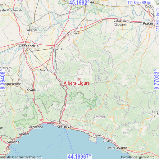
Albera Ligure GPS coordinates[2]
44° 42' 5.724" North, 9° 4' 1.92" East
| Map corner | latitude | longitude |
|---|---|---|
| Upper-left | 45.1992°, | 8.36408° |
| Center: | 44.70159°, | 9.0672° |
| Lower-right: | 44.19967°, | 9.77033° |
| Map W x H: | 111.1×111.1 km | = 69×69mi |
| max Lat: | 47.04031° ⇑45.7% North |
| Albera Ligure: | 44.70159° |
| min Lat: | ⇓54.3% South 35.50142° |
| min Long | Albera Ligure | max Long |
| 6.69888° | 9.0672° | 18.48682° |
| W 19.7%⇐ | ⇒80.3% E |
Elevation
Elevation of Albera Ligure is 422 m = 1385 ft, and this is 115.3 m = 378 ft above average elevation for this country.
| Max E: |
2085 m = 6841 ft | 27.3% |
| Albera Ligure | 422 m 1385 ft | |
| Avg. | 306.7 m = 1006 ft | |
Min E: |
-4 m = -13 ft | 72.7% |
See also: Italy elevation on elevation.city.
Geographical zone
Albera Ligure is located in North temperate zone (between Tropic of Cancer and the Arctic Circle). Distance of this Northern Tropic circle is 2364.4 km =1469.2 mi to South.| Distance of | km | miles | from Albera Ligure |
|---|---|---|---|
| North Pole | 5036.7 | 3129.7 | to North |
| Arctic Circle | 2430.8 | 1510.4 | to North |
| Tropic Cancer | 2364.4 | 1469.2 | to South |
| Equator | 4970.4 | 3088.5 | to South |


Nearby cities:
15 places around Albera Ligure: (largest is in red/bold)
• Borghetto di Borbera
10.3 km =6.4 mi,  287°
287°
• Cabella Ligure
3.7 km =2.3 mi,  142°
142°
• Cantalupo Ligure
2.5 km =1.6 mi,  317°
317°
• Dernice
7.4 km =4.6 mi,  349°
349°
• Garadassi
9 km =5.6 mi,  49°
49°
• Garbagna
10.3 km =6.4 mi,  328°
328°
• Gremiasco
11 km =6.8 mi,  16°
16°
• Grondona
8.1 km =5 mi,  265°
265°
• Isola del Cantone
10.5 km =6.5 mi,  235°
235°
• Mongiardino Ligure
7.5 km =4.7 mi,  181°
181°
• Montacuto
7.8 km =4.8 mi, 22°
• Roccaforte Ligure
4.1 km =2.5 mi,  229°
229°
• Rocchetta Ligure
1.4 km =0.9 mi, 292°
• San Sebastiano Curone
9.4 km =5.8 mi,  358°
358°
• Torreratti-Persi
8.7 km =5.4 mi, 293°
Sources, notices
• [Note1] Compared only with cities in Italy existing in our database
• [Src1] Map data: © OpenStreetMap contributors (CC-BY-SA)
• [Src2] Other city data from geonames.org with taken over terms of usage.
• [Src3] Geographical zone / Annual Mean Temperature by Robert A. Rohde @ Wikipedia
