Pregola geodata
Pregola (Lombardy) is a seat of a third-order administrative division; located in Italy in Europe/Rome (GMT+2) time zone. With population of 28 people, there are 11653 cities with bigger population in this country. Compared to other cities in Italy, 55.2% of cities are located further ↓South; 76.6% of cities are located further →East and 97.2% of cities have lower elevation than Pregola. Note1
Administrative division(s):
- Level 1: Lombardy
- Level 2: Provincia di Pavia
- Level 3: Brallo di Pregola


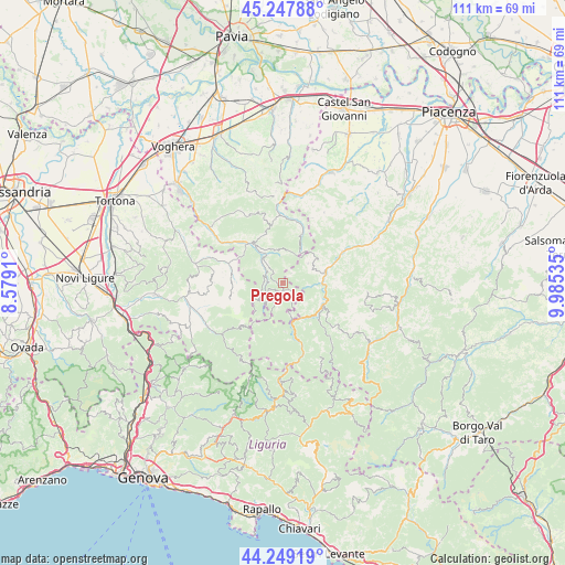
Pregola GPS coordinates[2]
44° 45' 2.484" North, 9° 16' 56.028" East
| Map corner | latitude | longitude |
|---|---|---|
| Upper-left | 45.24788°, | 8.5791° |
| Center: | 44.75069°, | 9.28223° |
| Lower-right: | 44.24919°, | 9.98535° |
| Map W x H: | 111×111 km | = 69×69mi |
| max Lat: | 47.04031° ⇑44.8% North |
| Pregola: | 44.75069° |
| min Lat: | ⇓55.2% South 35.50142° |
| min Long | Pregola | max Long |
| 6.69888° | 9.28223° | 18.48682° |
| W 23.4%⇐ | ⇒76.6% E |
Elevation
Elevation of Pregola is 1015 m = 3330 ft, and this is 708.3 m = 2324 ft above average elevation for this country.
| Max E: |
2085 m = 6841 ft | 2.8% |
| Pregola | 1015 m 3330 ft | |
| Avg. | 306.7 m = 1006 ft | |
Min E: |
-4 m = -13 ft | 97.2% |
See also: Italy elevation on elevation.city.
Geographical zone
Pregola is located in North temperate zone (between Tropic of Cancer and the Arctic Circle). Distance of this Northern Tropic circle is 2369.9 km =1472.6 mi to South.| Distance of | km | miles | from Pregola |
|---|---|---|---|
| North Pole | 5031.3 | 3126.3 | to North |
| Arctic Circle | 2425.4 | 1507.1 | to North |
| Tropic Cancer | 2369.9 | 1472.6 | to South |
| Equator | 4975.8 | 3091.8 | to South |


Nearby cities:
15 places around Pregola: (largest is in red/bold)
• Bobbio
8.3 km =5.2 mi,  76°
76°
• Cerignale
9.7 km =6 mi,  146°
146°
• Coli
10.5 km =6.5 mi,  92°
92°
• Garadassi
10.1 km =6.3 mi,  272°
272°
• Gremiasco
14.7 km =9.1 mi,  290°
290°
• Marsaglia
9.1 km =5.7 mi,  118°
118°
• Menconico
5.1 km =3.2 mi,  357°
357°
• Mombelli
13.6 km =8.5 mi,  343°
343°
• Montacuto
14.1 km =8.8 mi,  277°
277°
• Ottone
14.7 km =9.1 mi,  164°
164°
• Romagnese
10.7 km =6.6 mi,  19°
19°
• Santa Margherita di Staffora
4.1 km =2.5 mi,  304°
304°
• Varzi
10.4 km =6.5 mi,  320°
320°
• Zavattarello
13.1 km =8.1 mi,  354°
354°
• Zerba
9.5 km =5.9 mi,  177°
177°
Sources, notices
• [Note1] Compared only with cities in Italy existing in our database
• [Src1] Map data: © OpenStreetMap contributors (CC-BY-SA)
• [Src2] Other city data from geonames.org with taken over terms of usage.
• [Src3] Geographical zone / Annual Mean Temperature by Robert A. Rohde @ Wikipedia
