Montacuto geodata
Montacuto (Piedmont) is a seat of a third-order administrative division; located in Italy in Europe/Rome (GMT+2) time zone. With population of 15 people, there are 11687 cities with bigger population in this country. Compared to other cities in Italy, 55.6% of cities are located further ↓South; 79.6% of cities are located further →East and 81.2% of cities have lower elevation than Montacuto. Note1


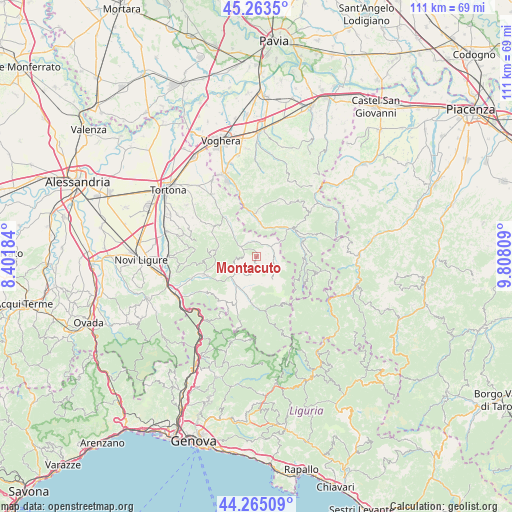
Montacuto GPS coordinates[2]
44° 45' 59.22" North, 9° 6' 17.856" East
| Map corner | latitude | longitude |
|---|---|---|
| Upper-left | 45.2635°, | 8.40184° |
| Center: | 44.76645°, | 9.10496° |
| Lower-right: | 44.26509°, | 9.80809° |
| Map W x H: | 111×111 km | = 69×69mi |
| max Lat: | 47.04031° ⇑44.4% North |
| Montacuto: | 44.76645° |
| min Lat: | ⇓55.6% South 35.50142° |
| min Long | Montacuto | max Long |
| 6.69888° | 9.10496° | 18.48682° |
| W 20.4%⇐ | ⇒79.6% E |
Elevation
Elevation of Montacuto is 542 m = 1778 ft, and this is 235.3 m = 772 ft above average elevation for this country.
| Max E: |
2085 m = 6841 ft | 18.8% |
| Montacuto | 542 m 1778 ft | |
| Avg. | 306.7 m = 1006 ft | |
Min E: |
-4 m = -13 ft | 81.2% |
See also: Italy elevation on elevation.city.
Geographical zone
Montacuto is located in North temperate zone (between Tropic of Cancer and the Arctic Circle). Distance of this Northern Tropic circle is 2371.6 km =1473.6 mi to South.| Distance of | km | miles | from Montacuto |
|---|---|---|---|
| North Pole | 5029.5 | 3125.2 | to North |
| Arctic Circle | 2423.6 | 1506 | to North |
| Tropic Cancer | 2371.6 | 1473.6 | to South |
| Equator | 4977.6 | 3092.9 | to South |


Nearby cities:
15 places around Montacuto: (largest is in red/bold)
• Albera Ligure
7.8 km =4.8 mi,  202°
202°
• Bagnaria
6.9 km =4.3 mi,  11°
11°
• Brignano
7.4 km =4.6 mi,  316°
316°
• Cabella Ligure
10.2 km =6.3 mi,  183°
183°
• Cantalupo Ligure
7.1 km =4.4 mi,  221°
221°
• Cecima
9.6 km =6 mi,  348°
348°
• Dernice
4.3 km =2.7 mi,  270°
270°
• Garadassi
4.1 km =2.5 mi,  109°
109°
• Garbagna
8.6 km =5.3 mi,  280°
280°
• Gremiasco
3.3 km =2.1 mi,  2°
2°
• Momperone
9.8 km =6.1 mi,  325°
325°
• Ponte Nizza
9.5 km =5.9 mi,  356°
356°
• Rocchetta Ligure
7.9 km =4.9 mi,  212°
212°
• San Sebastiano Curone
3.9 km =2.4 mi,  304°
304°
• Varzi
9.6 km =6 mi,  49°
49°
Sources, notices
• [Note1] Compared only with cities in Italy existing in our database
• [Src1] Map data: © OpenStreetMap contributors (CC-BY-SA)
• [Src2] Other city data from geonames.org with taken over terms of usage.
• [Src3] Geographical zone / Annual Mean Temperature by Robert A. Rohde @ Wikipedia
