Frisa geodata
Frisa (Abruzzo) is a seat of a third-order administrative division; located in Italy in Europe/Rome (GMT+2) time zone. With population of 1,423 people, there are 5310 cities with bigger population in this country. Compared to other cities in Italy, 68.1% of cities are located further ↑North; 81.6% of cities are located further ←West and 50.3% of cities have higher elevation than Frisa. Note1


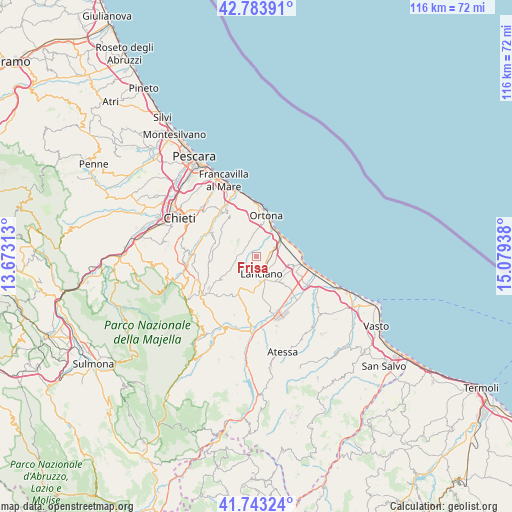
Frisa GPS coordinates[2]
42° 15' 56.592" North, 14° 22' 34.5" East
| Map corner | latitude | longitude |
|---|---|---|
| Upper-left | 42.78391°, | 13.67313° |
| Center: | 42.26572°, | 14.37625° |
| Lower-right: | 41.74324°, | 15.07938° |
| Map W x H: | 115.7×115.7 km | = 71.9×71.9mi |
| max Lat: | 47.04031° ⇑68.1% North |
| Frisa: | 42.26572° |
| min Lat: | ⇓31.9% South 35.50142° |
| min Long | Frisa | max Long |
| 6.69888° | 14.37625° | 18.48682° |
| W 81.6%⇐ | ⇒18.4% E |
Elevation
Elevation of Frisa is 233 m = 764 ft, and this is 73.7 m = 242 ft below average elevation for this country.
| Max E: |
2085 m = 6841 ft | 50.3% |
| Avg. | 306.7 m = 1006 ft | |
| Frisa | 233 m = 764 ft | |
Min E: |
-4 m = -13 ft | 49.7% |
See also: Italy elevation on elevation.city.
Geographical zone
Frisa is located in North temperate zone (between Tropic of Cancer and the Arctic Circle). Distance of this Northern Tropic circle is 2093.6 km =1300.9 mi to South.| Distance of | km | miles | from Frisa |
|---|---|---|---|
| North Pole | 5307.6 | 3298 | to North |
| Arctic Circle | 2701.7 | 1678.8 | to North |
| Tropic Cancer | 2093.6 | 1300.9 | to South |
| Equator | 4699.5 | 2920.1 | to South |


Nearby cities:
15 places around Frisa: (largest is in red/bold)
• Arielli
5.5 km =3.4 mi,  263°
263°
• Canosa Sannita
6.8 km =4.2 mi,  300°
300°
• Castel Frentano
7.6 km =4.7 mi,  192°
192°
• Crecchio
5.4 km =3.4 mi,  311°
311°
• Lanciano
4.4 km =2.7 mi,  164°
164°
• Marina di San Vito
7.4 km =4.6 mi,  53°
53°
• Poggiofiorito
4.7 km =2.9 mi,  254°
254°
• Rocca San Giovanni
7.4 km =4.6 mi,  107°
107°
• San Vito Chietino
6.1 km =3.8 mi,  63°
63°
• Sant'Amato-Nasuti
3.4 km =2.1 mi,  209°
209°
• Sant'Apollinare
4.4 km =2.7 mi,  38°
38°
• Treglio
3.9 km =2.4 mi,  96°
96°
• Villa Caldari
3.5 km =2.2 mi,  340°
340°
• Villa Grande
7.1 km =4.4 mi,  351°
351°
• Villa San Leonardo
5.4 km =3.4 mi,  21°
21°
Sources, notices
• [Note1] Compared only with cities in Italy existing in our database
• [Src1] Map data: © OpenStreetMap contributors (CC-BY-SA)
• [Src2] Other city data from geonames.org with taken over terms of usage.
• [Src3] Geographical zone / Annual Mean Temperature by Robert A. Rohde @ Wikipedia
