San Vito Chietino geodata
San Vito Chietino (Abruzzo) is a seat of a third-order administrative division; located in Italy in Europe/Rome (GMT+2) time zone. With population of 2,009 people, there are 4136 cities with bigger population in this country. Compared to other cities in Italy, 67.9% of cities are located further ↑North; 82.1% of cities are located further ←West and 62.6% of cities have higher elevation than San Vito Chietino. Note1
Administrative division(s):
- Level 1: Abruzzo
- Level 2: Provincia di Chieti
- Level 3: San Vito Chietino


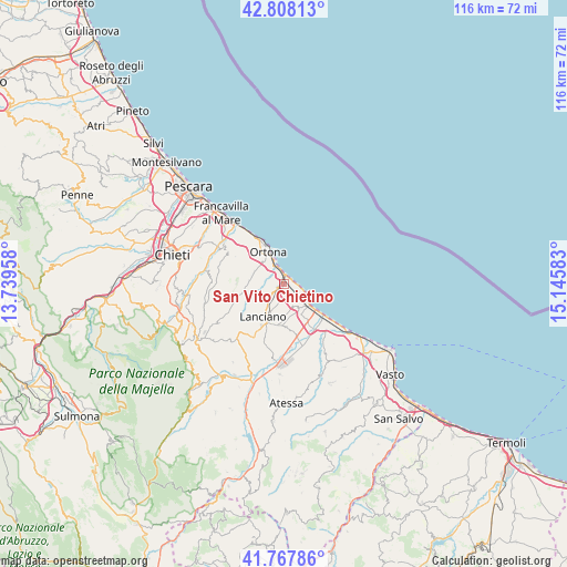
San Vito Chietino GPS coordinates[2]
42° 17' 24.504" North, 14° 26' 33.72" East
| Map corner | latitude | longitude |
|---|---|---|
| Upper-left | 42.80813°, | 13.73958° |
| Center: | 42.29014°, | 14.4427° |
| Lower-right: | 41.76786°, | 15.14583° |
| Map W x H: | 115.7×115.7 km | = 71.9×71.9mi |
| max Lat: | 47.04031° ⇑67.9% North |
| San Vito Chietino: | 42.29014° |
| min Lat: | ⇓32.1% South 35.50142° |
| min Long | San Vito Chieti | max Long |
| 6.69888° | 14.4427° | 18.48682° |
| W 82.1%⇐ | ⇒17.9% E |
Elevation
Elevation of San Vito Chietino is 144 m = 472 ft, and this is 162.7 m = 534 ft below average elevation for this country.
| Max E: |
2085 m = 6841 ft | 62.6% |
| Avg. | 306.7 m = 1006 ft | |
| San Vito Chietino | 144 m = 472 ft | |
Min E: |
-4 m = -13 ft | 37.4% |
See also: Italy elevation on elevation.city.
Geographical zone
San Vito Chietino is located in North temperate zone (between Tropic of Cancer and the Arctic Circle). Distance of this Northern Tropic circle is 2096.3 km =1302.6 mi to South.| Distance of | km | miles | from San Vito Chietino |
|---|---|---|---|
| North Pole | 5304.8 | 3296.2 | to North |
| Arctic Circle | 2699 | 1677.1 | to North |
| Tropic Cancer | 2096.3 | 1302.6 | to South |
| Equator | 4702.2 | 2921.8 | to South |


Nearby cities:
15 places around San Vito Chietino: (largest is in red/bold)
• Fossacesia
6.3 km =3.9 mi,  147°
147°
• Frisa
6.1 km =3.8 mi,  243°
243°
• Lanciano
8.2 km =5.1 mi,  211°
211°
• Marina di San Vito
1.7 km =1.1 mi,  15°
15°
• Mozzagrogna
8.6 km =5.3 mi,  180°
180°
• Ortona
7.5 km =4.7 mi,  334°
334°
• Rocca San Giovanni
5.1 km =3.2 mi,  162°
162°
• Sant'Amato-Nasuti
9.1 km =5.7 mi,  231°
231°
• Sant'Apollinare
2.8 km =1.7 mi,  284°
284°
• Santa Lucia
5.7 km =3.5 mi, 325°
• Santa Maria Imbaro
7.8 km =4.8 mi, 175°
• Treglio
3.5 km =2.2 mi, 207°
• Villa Caldari
6.7 km =4.2 mi, 275°
• Villa Grande
7.8 km =4.8 mi,  303°
303°
• Villa San Leonardo
4.2 km =2.6 mi, 303°
Sources, notices
• [Note1] Compared only with cities in Italy existing in our database
• [Src1] Map data: © OpenStreetMap contributors (CC-BY-SA)
• [Src2] Other city data from geonames.org with taken over terms of usage.
• [Src3] Geographical zone / Annual Mean Temperature by Robert A. Rohde @ Wikipedia
