Fossombrone geodata
Fossombrone (The Marches) is a seat of a third-order administrative division; located in Italy in Europe/Rome (GMT+2) time zone. With population of 6,808 people, there are 1439 cities with bigger population in this country. Compared to other cities in Italy, 58.2% of cities are located further ↑North; 66.3% of cities are located further ←West and 67.1% of cities have higher elevation than Fossombrone. Note1
Administrative division(s):
- Level 1: The Marches
- Level 2: Provincia di Pesaro e Urbino
- Level 3: Fossombrone


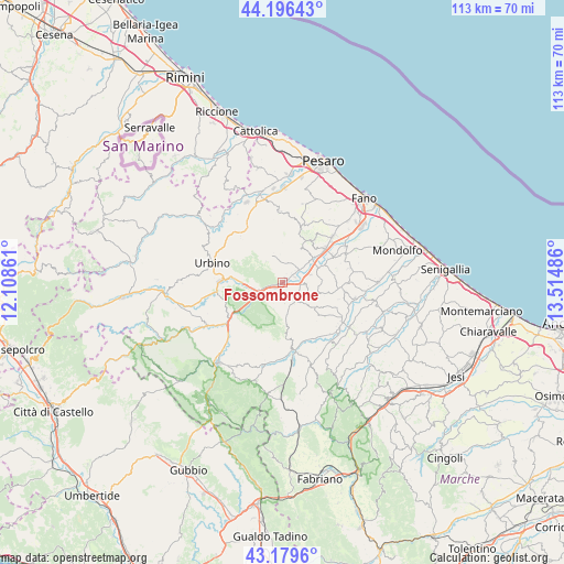
Fossombrone GPS coordinates[2]
43° 41' 24.612" North, 12° 48' 42.228" East
| Map corner | latitude | longitude |
|---|---|---|
| Upper-left | 44.19643°, | 12.10861° |
| Center: | 43.69017°, | 12.81173° |
| Lower-right: | 43.1796°, | 13.51486° |
| Map W x H: | 113.1×113.1 km | = 70.3×70.3mi |
| max Lat: | 47.04031° ⇑58.2% North |
| Fossombrone: | 43.69017° |
| min Lat: | ⇓41.8% South 35.50142° |
| min Long | Fossombrone | max Long |
| 6.69888° | 12.81173° | 18.48682° |
| W 66.3%⇐ | ⇒33.7% E |
Elevation
Elevation of Fossombrone is 115 m = 377 ft, and this is 191.7 m = 629 ft below average elevation for this country.
| Max E: |
2085 m = 6841 ft | 67.1% |
| Avg. | 306.7 m = 1006 ft | |
| Fossombrone | 115 m = 377 ft | |
Min E: |
-4 m = -13 ft | 32.9% |
See also: Italy elevation on elevation.city.
Geographical zone
Fossombrone is located in North temperate zone (between Tropic of Cancer and the Arctic Circle). Distance of this Northern Tropic circle is 2252 km =1399.3 mi to South.| Distance of | km | miles | from Fossombrone |
|---|---|---|---|
| North Pole | 5149.2 | 3199.6 | to North |
| Arctic Circle | 2543.3 | 1580.3 | to North |
| Tropic Cancer | 2252 | 1399.3 | to South |
| Equator | 4857.9 | 3018.6 | to South |


Nearby cities:
15 places around Fossombrone: (largest is in red/bold)
• Barchi
9.6 km =6 mi,  101°
101°
• Borgaccio
9.8 km =6.1 mi,  52°
52°
• Calcinelli
11.2 km =7 mi, 50°
• Canavaccio
9.1 km =5.7 mi,  272°
272°
• Cartoceto
10.2 km =6.3 mi,  34°
34°
• Fratte Rosa
9.6 km =6 mi,  130°
130°
• Isola del Piano
5.7 km =3.5 mi,  337°
337°
• Montefelcino
5.3 km =3.3 mi,  19°
19°
• Montemaggiore al Metauro
11.9 km =7.4 mi,  64°
64°
• Petriano
11.8 km =7.3 mi,  327°
327°
• Saltara
9.8 km =6.1 mi, 45°
• Sant'Ippolito
5.3 km =3.3 mi, 102°
• Serrungarina
8.1 km =5 mi,  38°
38°
• Tavernelle
7.4 km =4.6 mi, 51°
• Villanova
11.3 km =7 mi, 61°
Sources, notices
• [Note1] Compared only with cities in Italy existing in our database
• [Src1] Map data: © OpenStreetMap contributors (CC-BY-SA)
• [Src2] Other city data from geonames.org with taken over terms of usage.
• [Src3] Geographical zone / Annual Mean Temperature by Robert A. Rohde @ Wikipedia
