Fratte Rosa geodata
Fratte Rosa (The Marches) is a seat of a third-order administrative division; located in Italy in Europe/Rome (GMT+2) time zone. With population of 525 people, there are 9685 cities with bigger population in this country. Compared to other cities in Italy, 58.7% of cities are located further ↑North; 67.2% of cities are located further ←West and 70.9% of cities have lower elevation than Fratte Rosa. Note1
Administrative division(s):
- Level 1: The Marches
- Level 2: Provincia di Pesaro e Urbino
- Level 3: Fratte Rosa


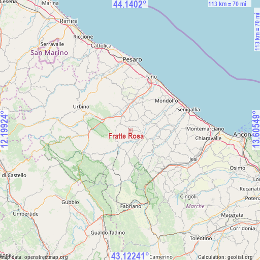
Fratte Rosa GPS coordinates[2]
43° 38' 0.456" North, 12° 54' 8.496" East
| Map corner | latitude | longitude |
|---|---|---|
| Upper-left | 44.1402°, | 12.19924° |
| Center: | 43.63346°, | 12.90236° |
| Lower-right: | 43.12241°, | 13.60549° |
| Map W x H: | 113.2×113.2 km | = 70.3×70.3mi |
| max Lat: | 47.04031° ⇑58.7% North |
| Fratte Rosa: | 43.63346° |
| min Lat: | ⇓41.3% South 35.50142° |
| min Long | Fratte Rosa | max Long |
| 6.69888° | 12.90236° | 18.48682° |
| W 67.2%⇐ | ⇒32.8% E |
Elevation
Elevation of Fratte Rosa is 403 m = 1322 ft, and this is 96.3 m = 316 ft above average elevation for this country.
| Max E: |
2085 m = 6841 ft | 29.1% |
| Fratte Rosa | 403 m 1322 ft | |
| Avg. | 306.7 m = 1006 ft | |
Min E: |
-4 m = -13 ft | 70.9% |
See also: Italy elevation on elevation.city.
Geographical zone
Fratte Rosa is located in North temperate zone (between Tropic of Cancer and the Arctic Circle). Distance of this Northern Tropic circle is 2245.7 km =1395.4 mi to South.| Distance of | km | miles | from Fratte Rosa |
|---|---|---|---|
| North Pole | 5155.5 | 3203.5 | to North |
| Arctic Circle | 2549.6 | 1584.2 | to North |
| Tropic Cancer | 2245.7 | 1395.4 | to South |
| Equator | 4851.6 | 3014.6 | to South |


Nearby cities:
15 places around Fratte Rosa: (largest is in red/bold)
• Barbara
11.7 km =7.3 mi,  120°
120°
• Barchi
4.8 km =3 mi,  25°
25°
• Borgaccio
12.2 km =7.6 mi,  2°
2°
• Castelleone di Suasa
6.7 km =4.2 mi,  114°
114°
• Fossombrone
9.6 km =6 mi,  310°
310°
• Mondavio
6.9 km =4.3 mi,  48°
48°
• Montemaggiore al Metauro
12 km =7.5 mi,  16°
16°
• Orciano di Pesaro
8.4 km =5.2 mi,  42°
42°
• Pergola
10.2 km =6.3 mi,  211°
211°
• San Giorgio di Pesaro
11.7 km =7.3 mi, 32°
• San Lorenzo in Campo
4.9 km =3 mi,  136°
136°
• San Michele
8.3 km =5.2 mi,  67°
67°
• Sant'Ippolito
5.6 km =3.5 mi,  337°
337°
• Tavernelle
11.1 km =6.9 mi,  352°
352°
• Villanova
12.1 km =7.5 mi,  12°
12°
Sources, notices
• [Note1] Compared only with cities in Italy existing in our database
• [Src1] Map data: © OpenStreetMap contributors (CC-BY-SA)
• [Src2] Other city data from geonames.org with taken over terms of usage.
• [Src3] Geographical zone / Annual Mean Temperature by Robert A. Rohde @ Wikipedia
