Calcinaia geodata
Calcinaia (Tuscany) is a seat of a third-order administrative division; located in Italy in Europe/Rome (GMT+2) time zone. With population of 3,157 people, there are 2922 cities with bigger population in this country. Compared to other cities in Italy, 58.3% of cities are located further ↑North; 61.7% of cities are located further →East and 91.1% of cities have higher elevation than Calcinaia. Note1


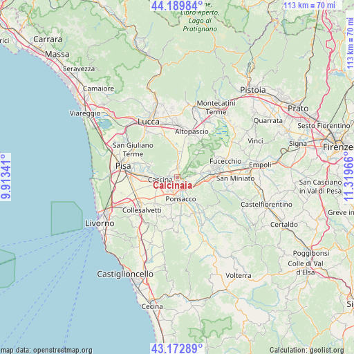
Calcinaia GPS coordinates[2]
43° 41' 0.672" North, 10° 36' 59.508" East
| Map corner | latitude | longitude |
|---|---|---|
| Upper-left | 44.18984°, | 9.91341° |
| Center: | 43.68352°, | 10.61653° |
| Lower-right: | 43.17289°, | 11.31966° |
| Map W x H: | 113.1×113.1 km | = 70.3×70.3mi |
| max Lat: | 47.04031° ⇑58.3% North |
| Calcinaia: | 43.68352° |
| min Lat: | ⇓41.7% South 35.50142° |
| min Long | Calcinaia | max Long |
| 6.69888° | 10.61653° | 18.48682° |
| W 38.3%⇐ | ⇒61.7% E |
Elevation
Elevation of Calcinaia is 16 m = 52 ft, and this is 290.7 m = 954 ft below average elevation for this country.
| Max E: |
2085 m = 6841 ft | 91.1% |
| Avg. | 306.7 m = 1006 ft | |
| Calcinaia | 16 m = 52 ft | |
Min E: |
-4 m = -13 ft | 8.9% |
See also: Italy elevation on elevation.city.
Geographical zone
Calcinaia is located in North temperate zone (between Tropic of Cancer and the Arctic Circle). Distance of this Northern Tropic circle is 2251.2 km =1398.8 mi to South.| Distance of | km | miles | from Calcinaia |
|---|---|---|---|
| North Pole | 5149.9 | 3200 | to North |
| Arctic Circle | 2544 | 1580.8 | to North |
| Tropic Cancer | 2251.2 | 1398.8 | to South |
| Equator | 4857.2 | 3018.1 | to South |


Nearby cities:
15 places around Calcinaia: (largest is in red/bold)
• Bientina
2.8 km =1.7 mi,  7°
7°
• Buti
5.6 km =3.5 mi,  332°
332°
• Cascina
5 km =3.1 mi,  259°
259°
• Cascine-La Croce
5 km =3.1 mi,  358°
358°
• Chiesino-Collodi
0.6 km =0.4 mi,  224°
224°
• Fornacette
2.9 km =1.8 mi,  239°
239°
• Il Romito
4.5 km =2.8 mi,  148°
148°
• La Borra
4.6 km =2.9 mi,  167°
167°
• La Rotta
5.7 km =3.5 mi,  119°
119°
• Latignano
5.6 km =3.5 mi, 235°
• Montecalvoli
3.9 km =2.4 mi,  86°
86°
• Pontedera
2.7 km =1.7 mi,  155°
155°
• Quattro Strade
4.4 km =2.7 mi,  49°
49°
• Santa Lucia
4.4 km =2.7 mi,  185°
185°
• Vicopisano
2.9 km =1.8 mi,  291°
291°
Sources, notices
• [Note1] Compared only with cities in Italy existing in our database
• [Src1] Map data: © OpenStreetMap contributors (CC-BY-SA)
• [Src2] Other city data from geonames.org with taken over terms of usage.
• [Src3] Geographical zone / Annual Mean Temperature by Robert A. Rohde @ Wikipedia
