Agliana geodata
Agliana (Tuscany) is a seat of a third-order administrative division; located in Italy in Europe/Rome (GMT+2) time zone. With population of 14,561 people, there are 622 cities with bigger population in this country. Compared to other cities in Italy, 55.7% of cities are located further ↑North; 57.3% of cities are located further →East and 81.2% of cities have higher elevation than Agliana. Note1


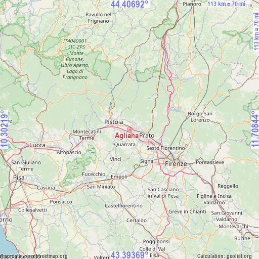
Agliana GPS coordinates[2]
43° 54' 8.856" North, 11° 0' 19.116" East
| Map corner | latitude | longitude |
|---|---|---|
| Upper-left | 44.40692°, | 10.30219° |
| Center: | 43.90246°, | 11.00531° |
| Lower-right: | 43.39369°, | 11.70844° |
| Map W x H: | 112.7×112.7 km | = 70×70mi |
| max Lat: | 47.04031° ⇑55.7% North |
| Agliana: | 43.90246° |
| min Lat: | ⇓44.3% South 35.50142° |
| min Long | Agliana | max Long |
| 6.69888° | 11.00531° | 18.48682° |
| W 42.7%⇐ | ⇒57.3% E |
Elevation
Elevation of Agliana is 45 m = 148 ft, and this is 261.7 m = 859 ft below average elevation for this country.
| Max E: |
2085 m = 6841 ft | 81.2% |
| Avg. | 306.7 m = 1006 ft | |
| Agliana | 45 m = 148 ft | |
Min E: |
-4 m = -13 ft | 18.8% |
See also: Italy elevation on elevation.city.
Geographical zone
Agliana is located in North temperate zone (between Tropic of Cancer and the Arctic Circle). Distance of this Northern Tropic circle is 2275.6 km =1414 mi to South.| Distance of | km | miles | from Agliana |
|---|---|---|---|
| North Pole | 5125.6 | 3184.9 | to North |
| Arctic Circle | 2519.7 | 1565.7 | to North |
| Tropic Cancer | 2275.6 | 1414 | to South |
| Equator | 4881.5 | 3033.2 | to South |


Nearby cities:
15 places around Agliana: (largest is in red/bold)
• Barba
3.2 km =2 mi,  227°
227°
• Caserana
4.3 km =2.7 mi,  171°
171°
• Casini
4.9 km =3 mi,  184°
184°
• Catena
6.7 km =4.2 mi, 172°
• Fognano
6.1 km =3.8 mi,  23°
23°
• Fornacelle
3.4 km =2.1 mi,  45°
45°
• Montale
3.7 km =2.3 mi,  14°
14°
• Montemurlo
3.7 km =2.3 mi,  43°
43°
• Pistoia
7.3 km =4.5 mi,  295°
295°
• Quarrata
6.4 km =4 mi,  199°
199°
• Santonuovo
6.4 km =4 mi, 229°
• Stazione
1.5 km =0.9 mi,  27°
27°
• Tobbiana
7.4 km =4.6 mi, 23°
• Valenzatico
5.1 km =3.2 mi,  219°
219°
• Vignole-Olmi
4.1 km =2.5 mi, 196°
Sources, notices
• [Note1] Compared only with cities in Italy existing in our database
• [Src1] Map data: © OpenStreetMap contributors (CC-BY-SA)
• [Src2] Other city data from geonames.org with taken over terms of usage.
• [Src3] Geographical zone / Annual Mean Temperature by Robert A. Rohde @ Wikipedia
