Palazzo del Pero geodata
Palazzo del Pero (Tuscany) is a populated place; located in Italy in Europe/Rome (GMT+2) time zone. With population of 645 people, there are 8670 cities with bigger population in this country. Compared to other cities in Italy, 60.4% of cities are located further ↑North; 55.5% of cities are located further ←West and 70.9% of cities have lower elevation than Palazzo del Pero. Note1


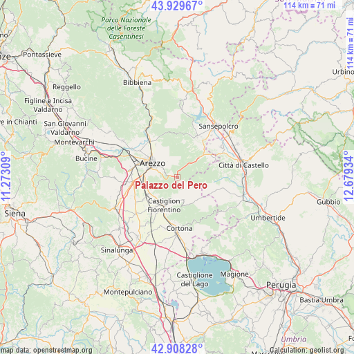
Palazzo del Pero GPS coordinates[2]
43° 25' 16.068" North, 11° 58' 34.356" East
| Map corner | latitude | longitude |
|---|---|---|
| Upper-left | 43.92967°, | 11.27309° |
| Center: | 43.42113°, | 11.97621° |
| Lower-right: | 42.90828°, | 12.67934° |
| Map W x H: | 113.6×113.6 km | = 70.6×70.6mi |
| max Lat: | 47.04031° ⇑60.4% North |
| Palazzo del Pero: | 43.42113° |
| min Lat: | ⇓39.6% South 35.50142° |
| min Long | Palazzo del Per | max Long |
| 6.69888° | 11.97621° | 18.48682° |
| W 55.5%⇐ | ⇒44.5% E |
Elevation
Elevation of Palazzo del Pero is 403 m = 1322 ft, and this is 96.3 m = 316 ft above average elevation for this country.
| Max E: |
2085 m = 6841 ft | 29.1% |
| Palazzo del Pero | 403 m 1322 ft | |
| Avg. | 306.7 m = 1006 ft | |
Min E: |
-4 m = -13 ft | 70.9% |
See also: Italy elevation on elevation.city.
Geographical zone
Palazzo del Pero is located in North temperate zone (between Tropic of Cancer and the Arctic Circle). Distance of this Northern Tropic circle is 2222.1 km =1380.7 mi to South.| Distance of | km | miles | from Palazzo del Pero |
|---|---|---|---|
| North Pole | 5179.1 | 3218.1 | to North |
| Arctic Circle | 2573.2 | 1598.9 | to North |
| Tropic Cancer | 2222.1 | 1380.7 | to South |
| Equator | 4828 | 3000 | to South |


Nearby cities:
15 places around Palazzo del Pero: (largest is in red/bold)
• Alberoro
14.9 km =9.3 mi,  246°
246°
• Anghiari
14.9 km =9.3 mi,  26°
26°
• Arezzo
9 km =5.6 mi,  300°
300°
• Battifolle-Ruscello-Poggiola
14.6 km =9.1 mi,  282°
282°
• Castiglion Fiorentino
9.8 km =6.1 mi,  207°
207°
• Chiassa-Tregozzano
12.3 km =7.6 mi,  326°
326°
• Citerna
14.1 km =8.8 mi,  52°
52°
• Fighille
15.2 km =9.4 mi,  44°
44°
• Giovi-Ponte alla Chiassa
14.7 km =9.1 mi,  322°
322°
• Monte Santa Maria Tiberina
15.1 km =9.4 mi,  83°
83°
• Montecchio
12.7 km =7.9 mi,  198°
198°
• Monterchi
13.1 km =8.1 mi,  55°
55°
• Pieve al Toppo
14.6 km =9.1 mi,  264°
264°
• Pitigliano
4.7 km =2.9 mi,  312°
312°
• Quarata
14.8 km =9.2 mi, 305°
Sources, notices
• [Note1] Compared only with cities in Italy existing in our database
• [Src1] Map data: © OpenStreetMap contributors (CC-BY-SA)
• [Src2] Other city data from geonames.org with taken over terms of usage.
• [Src3] Geographical zone / Annual Mean Temperature by Robert A. Rohde @ Wikipedia
