Entracque geodata
Entracque (Piedmont) is a seat of a third-order administrative division; located in Italy in Europe/Rome (GMT+2) time zone. With population of 722 people, there are 8141 cities with bigger population in this country. Compared to other cities in Italy, 52.4% of cities are located further ↑North; 98.3% of cities are located further →East and 95.3% of cities have lower elevation than Entracque. Note1


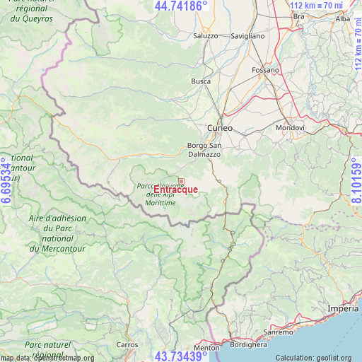
Entracque GPS coordinates[2]
44° 14' 25.008" North, 7° 23' 54.492" East
| Map corner | latitude | longitude |
|---|---|---|
| Upper-left | 44.74186°, | 6.69534° |
| Center: | 44.24028°, | 7.39847° |
| Lower-right: | 43.73439°, | 8.10159° |
| Map W x H: | 112×112 km | = 69.6×69.6mi |
| max Lat: | 47.04031° ⇑52.4% North |
| Entracque: | 44.24028° |
| min Lat: | ⇓47.6% South 35.50142° |
| min Long | Entracque | max Long |
| 6.69888° | 7.39847° | 18.48682° |
| W 1.7%⇐ | ⇒98.3% E |
Elevation
Elevation of Entracque is 892 m = 2927 ft, and this is 585.3 m = 1920 ft above average elevation for this country.
| Max E: |
2085 m = 6841 ft | 4.7% |
| Entracque | 892 m 2927 ft | |
| Avg. | 306.7 m = 1006 ft | |
Min E: |
-4 m = -13 ft | 95.3% |
See also: Italy elevation on elevation.city.
Geographical zone
Entracque is located in North temperate zone (between Tropic of Cancer and the Arctic Circle). Distance of this Northern Tropic circle is 2313.1 km =1437.3 mi to South.| Distance of | km | miles | from Entracque |
|---|---|---|---|
| North Pole | 5088 | 3161.5 | to North |
| Arctic Circle | 2482.1 | 1542.3 | to North |
| Tropic Cancer | 2313.1 | 1437.3 | to South |
| Equator | 4919.1 | 3056.6 | to South |


Nearby cities:
15 places around Entracque: (largest is in red/bold)
• Borgo San Dalmazzo
13.2 km =8.2 mi,  34°
34°
• Boves
15.5 km =9.6 mi,  49°
49°
• Demonte
11.6 km =7.2 mi,  316°
316°
• Gaiola
10.6 km =6.6 mi,  4°
4°
• Limone Piemonte
15 km =9.3 mi,  106°
106°
• Moiola
9 km =5.6 mi,  355°
355°
• Rittana
12.3 km =7.6 mi, 359°
• Roaschia
5.6 km =3.5 mi, 53°
• Robilante
10.9 km =6.8 mi,  57°
57°
• Roccasparvera
11.8 km =7.3 mi,  16°
16°
• Roccavione
10.3 km =6.4 mi,  38°
38°
• Valdieri
4.2 km =2.6 mi, 359°
• Valloriate
11 km =6.8 mi,  349°
349°
• Vernante
10.8 km =6.7 mi,  87°
87°
• Vignolo
14.9 km =9.3 mi, 23°
Sources, notices
• [Note1] Compared only with cities in Italy existing in our database
• [Src1] Map data: © OpenStreetMap contributors (CC-BY-SA)
• [Src2] Other city data from geonames.org with taken over terms of usage.
• [Src3] Geographical zone / Annual Mean Temperature by Robert A. Rohde @ Wikipedia
