Desio geodata
Desio (Lombardy) is a seat of a third-order administrative division; located in Italy in Europe/Rome (GMT+2) time zone. With population of 40,337 people, there are 177 cities with bigger population in this country. Compared to other cities in Italy, 77.8% of cities are located further ↓South; 78% of cities are located further →East and 55.6% of cities have higher elevation than Desio. Note1
Administrative division(s):
- Level 1: Lombardy
- Level 2: Provincia di Monza e della Brianza
- Level 3: Desio


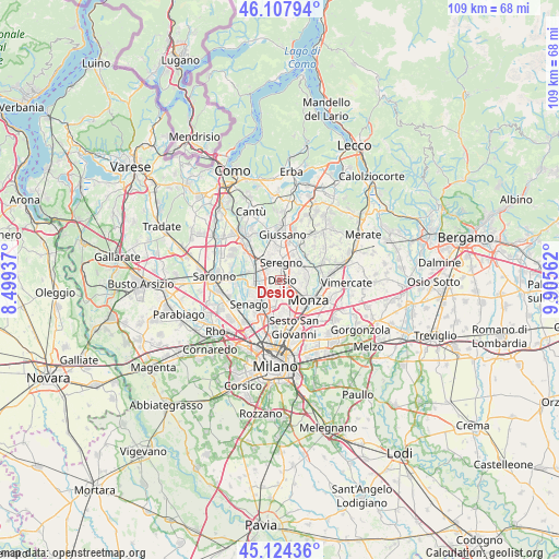
Desio GPS coordinates[2]
45° 37' 5.916" North, 9° 12' 8.964" East
| Map corner | latitude | longitude |
|---|---|---|
| Upper-left | 46.10794°, | 8.49937° |
| Center: | 45.61831°, | 9.20249° |
| Lower-right: | 45.12436°, | 9.90562° |
| Map W x H: | 109.4×109.4 km | = 68×68mi |
| max Lat: | 47.04031° ⇑22.2% North |
| Desio: | 45.61831° |
| min Lat: | ⇓77.8% South 35.50142° |
| min Long | Desio | max Long |
| 6.69888° | 9.20249° | 18.48682° |
| W 22%⇐ | ⇒78% E |
Elevation
Elevation of Desio is 198 m = 650 ft, and this is 108.7 m = 357 ft below average elevation for this country.
| Max E: |
2085 m = 6841 ft | 55.6% |
| Avg. | 306.7 m = 1006 ft | |
| Desio | 198 m = 650 ft | |
Min E: |
-4 m = -13 ft | 44.4% |
See also: Desio elevation on elevation.city.
Geographical zone
Desio is located in North temperate zone (between Tropic of Cancer and the Arctic Circle). Distance of this North polar circle is 2328.9 km =1447.1 mi to North.| Distance of | km | miles | from Desio |
|---|---|---|---|
| North Pole | 4934.8 | 3066.3 | to North |
| Arctic Circle | 2328.9 | 1447.1 | to North |
| Tropic Cancer | 2466.4 | 1532.5 | to South |
| Equator | 5072.3 | 3151.8 | to South |


Nearby cities:
15 places around Desio: (largest is in red/bold)
• Albiate
5.6 km =3.5 mi,  42°
42°
• Biassono
5.5 km =3.4 mi,  77°
77°
• Bovisio-Masciago
4 km =2.5 mi,  256°
256°
• Cesano Maderno
4.1 km =2.5 mi,  287°
287°
• Lissone
3 km =1.9 mi,  102°
102°
• Macherio
6 km =3.7 mi,  66°
66°
• Meda
6.1 km =3.8 mi,  321°
321°
• Muggiò
3.8 km =2.4 mi,  149°
149°
• Nova Milanese
3.3 km =2.1 mi,  186°
186°
• Santa Margherita
2.8 km =1.7 mi,  51°
51°
• Seregno
3.5 km =2.2 mi,  3°
3°
• Seveso
5.6 km =3.5 mi,  304°
304°
• Sovico
5.6 km =3.5 mi,  56°
56°
• Varedo
3.8 km =2.4 mi,  232°
232°
• Vedano al Lambro
5.2 km =3.2 mi, 101°
Sources, notices
• [Note1] Compared only with cities in Italy existing in our database
• [Src1] Map data: © OpenStreetMap contributors (CC-BY-SA)
• [Src2] Other city data from geonames.org with taken over terms of usage.
• [Src3] Geographical zone / Annual Mean Temperature by Robert A. Rohde @ Wikipedia
