Desenzano del Garda geodata
Desenzano del Garda (Lombardy) is a seat of a third-order administrative division; located in Italy in Europe/Rome (GMT+2) time zone. With population of 22,665 people, there are 379 cities with bigger population in this country. Compared to other cities in Italy, 72.6% of cities are located further ↓South; 62.4% of cities are located further →East and 72% of cities have higher elevation than Desenzano del Garda. Note1
Administrative division(s):
- Level 1: Lombardy
- Level 2: Provincia di Brescia
- Level 3: Desenzano del Garda


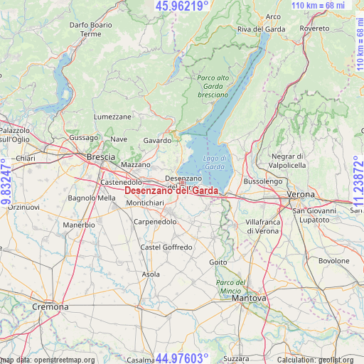
Desenzano del Garda GPS coordinates[2]
45° 28' 16.572" North, 10° 32' 8.124" East
| Map corner | latitude | longitude |
|---|---|---|
| Upper-left | 45.96219°, | 9.83247° |
| Center: | 45.47127°, | 10.53559° |
| Lower-right: | 44.97603°, | 11.23872° |
| Map W x H: | 109.7×109.6 km | = 68.2×68.1mi |
| max Lat: | 47.04031° ⇑27.4% North |
| Desenzano del Garda: | 45.47127° |
| min Lat: | ⇓72.6% South 35.50142° |
| min Long | Desenzano del G | max Long |
| 6.69888° | 10.53559° | 18.48682° |
| W 37.6%⇐ | ⇒62.4% E |
Elevation
Elevation of Desenzano del Garda is 88 m = 289 ft, and this is 218.7 m = 718 ft below average elevation for this country.
| Max E: |
2085 m = 6841 ft | 72% |
| Avg. | 306.7 m = 1006 ft | |
| Desenzano del Garda | 88 m = 289 ft | |
Min E: |
-4 m = -13 ft | 28% |
See also: Italy elevation on elevation.city.
Geographical zone
Desenzano del Garda is located in North temperate zone (between Tropic of Cancer and the Arctic Circle). Distance of this North polar circle is 2345.2 km =1457.2 mi to North.| Distance of | km | miles | from Desenzano del Garda |
|---|---|---|---|
| North Pole | 4951.1 | 3076.5 | to North |
| Arctic Circle | 2345.2 | 1457.2 | to North |
| Tropic Cancer | 2450 | 1522.4 | to South |
| Equator | 5055.9 | 3141.6 | to South |


Nearby cities:
15 places around Desenzano del Garda: (largest is in red/bold)
• Barcuzzi
3.6 km =2.2 mi,  298°
298°
• Carzago Riviera
8.3 km =5.2 mi,  315°
315°
• Esenta
7.5 km =4.7 mi,  215°
215°
• Lonato
4.7 km =2.9 mi,  255°
255°
• Manerba del Garda
8.8 km =5.5 mi,  8°
8°
• Moniga del Garda
6.2 km =3.9 mi,  1°
1°
• Padenghe sul Garda
4.3 km =2.7 mi,  341°
341°
• Piazza
9.7 km =6 mi, 295°
• Polpenazze del Garda
9.2 km =5.7 mi, 344°
• Ponte San Marco
9.6 km =6 mi,  273°
273°
• San Martino della Battaglia
6.3 km =3.9 mi,  125°
125°
• Sedena
5.2 km =3.2 mi,  289°
289°
• Sirmione
6.1 km =3.8 mi,  61°
61°
• Soiano
6.5 km =4 mi, 344°
• Solarolo
8.9 km =5.5 mi, 9°
Sources, notices
• [Note1] Compared only with cities in Italy existing in our database
• [Src1] Map data: © OpenStreetMap contributors (CC-BY-SA)
• [Src2] Other city data from geonames.org with taken over terms of usage.
• [Src3] Geographical zone / Annual Mean Temperature by Robert A. Rohde @ Wikipedia
