Sirmione geodata
Sirmione (Lombardy) is a seat of a third-order administrative division; located in Italy in Europe/Rome (GMT+2) time zone. With population of 6,818 people, there are 1434 cities with bigger population in this country. Compared to other cities in Italy, 73.6% of cities are located further ↓South; 61.8% of cities are located further →East and 71.3% of cities have higher elevation than Sirmione. Note1


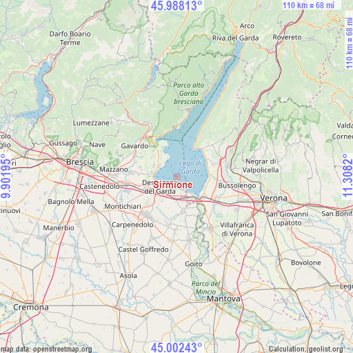
Sirmione GPS coordinates[2]
45° 29' 50.784" North, 10° 36' 18.252" East
| Map corner | latitude | longitude |
|---|---|---|
| Upper-left | 45.98813°, | 9.90195° |
| Center: | 45.49744°, | 10.60507° |
| Lower-right: | 45.00243°, | 11.3082° |
| Map W x H: | 109.6×109.6 km | = 68.1×68.1mi |
| max Lat: | 47.04031° ⇑26.4% North |
| Sirmione: | 45.49744° |
| min Lat: | ⇓73.6% South 35.50142° |
| min Long | Sirmione | max Long |
| 6.69888° | 10.60507° | 18.48682° |
| W 38.2%⇐ | ⇒61.8% E |
Elevation
Elevation of Sirmione is 91 m = 299 ft, and this is 215.7 m = 708 ft below average elevation for this country.
| Max E: |
2085 m = 6841 ft | 71.3% |
| Avg. | 306.7 m = 1006 ft | |
| Sirmione | 91 m = 299 ft | |
Min E: |
-4 m = -13 ft | 28.7% |
See also: Italy elevation on elevation.city.
Geographical zone
Sirmione is located in North temperate zone (between Tropic of Cancer and the Arctic Circle). Distance of this North polar circle is 2342.3 km =1455.4 mi to North.| Distance of | km | miles | from Sirmione |
|---|---|---|---|
| North Pole | 4948.2 | 3074.7 | to North |
| Arctic Circle | 2342.3 | 1455.4 | to North |
| Tropic Cancer | 2452.9 | 1524.2 | to South |
| Equator | 5058.8 | 3143.4 | to South |


Nearby cities:
15 places around Sirmione: (largest is in red/bold)
• Barcuzzi
8.7 km =5.4 mi,  262°
262°
• Desenzano del Garda
6.1 km =3.8 mi,  241°
241°
• Lazise
10.5 km =6.5 mi,  85°
85°
• Manerba del Garda
7.1 km =4.4 mi,  324°
324°
• Moniga del Garda
6.2 km =3.9 mi,  301°
301°
• Padenghe sul Garda
6.8 km =4.2 mi,  279°
279°
• Peschiera del Garda
9.1 km =5.7 mi,  135°
135°
• Pieve Vecchia
8.9 km =5.5 mi,  329°
329°
• Polpenazze del Garda
9.8 km =6.1 mi,  307°
307°
• Raffa
10 km =6.2 mi, 324°
• San Felice del Benaco
10.3 km =6.4 mi,  337°
337°
• San Martino della Battaglia
6.6 km =4.1 mi,  183°
183°
• Sedena
10.4 km =6.5 mi, 263°
• Soiano
8 km =5 mi, 295°
• Solarolo
7.1 km =4.4 mi, 326°
Sources, notices
• [Note1] Compared only with cities in Italy existing in our database
• [Src1] Map data: © OpenStreetMap contributors (CC-BY-SA)
• [Src2] Other city data from geonames.org with taken over terms of usage.
• [Src3] Geographical zone / Annual Mean Temperature by Robert A. Rohde @ Wikipedia
