Marne geodata
Marne (Lombardy) is a populated place; located in Italy in Europe/Rome (GMT+2) time zone. With population of 567 people, there are 9283 cities with bigger population in this country. Compared to other cities in Italy, 78% of cities are located further ↓South; 72.5% of cities are located further →East and 58.2% of cities have higher elevation than Marne. Note1


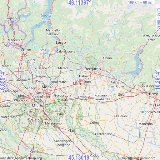
Marne GPS coordinates[2]
45° 37' 26.724" North, 9° 33' 29.772" East
| Map corner | latitude | longitude |
|---|---|---|
| Upper-left | 46.11367°, | 8.85514° |
| Center: | 45.62409°, | 9.55827° |
| Lower-right: | 45.13019°, | 10.2614° |
| Map W x H: | 109.4×109.4 km | = 68×68mi |
| max Lat: | 47.04031° ⇑22% North |
| Marne: | 45.62409° |
| min Lat: | ⇓78% South 35.50142° |
| min Long | Marne | max Long |
| 6.69888° | 9.55827° | 18.48682° |
| W 27.5%⇐ | ⇒72.5% E |
Elevation
Elevation of Marne is 178 m = 584 ft, and this is 128.7 m = 422 ft below average elevation for this country.
| Max E: |
2085 m = 6841 ft | 58.2% |
| Avg. | 306.7 m = 1006 ft | |
| Marne | 178 m = 584 ft | |
Min E: |
-4 m = -13 ft | 41.8% |
See also: Italy elevation on elevation.city.
Geographical zone
Marne is located in North temperate zone (between Tropic of Cancer and the Arctic Circle). Distance of this North polar circle is 2328.3 km =1446.7 mi to North.| Distance of | km | miles | from Marne |
|---|---|---|---|
| North Pole | 4934.1 | 3065.9 | to North |
| Arctic Circle | 2328.3 | 1446.7 | to North |
| Tropic Cancer | 2467 | 1532.9 | to South |
| Equator | 5072.9 | 3152.2 | to South |


Nearby cities:
15 places around Marne: (largest is in red/bold)
• Boltiere
3 km =1.9 mi,  148°
148°
• Bonate Sotto
4.9 km =3 mi,  0°
0°
• Bottanuco
4.2 km =2.6 mi,  293°
293°
• Brembate
2.2 km =1.4 mi,  187°
187°
• Capriate San Gervasio
2.5 km =1.6 mi,  240°
240°
• Ciserano
5.2 km =3.2 mi,  140°
140°
• Dalmine
4.7 km =2.9 mi,  52°
52°
• Filago
1.5 km =0.9 mi,  354°
354°
• Grignano
1.4 km =0.9 mi, 242°
• Levate
5.1 km =3.2 mi,  88°
88°
• Madone
3 km =1.9 mi, 347°
• Osio Sopra
2.1 km =1.3 mi,  74°
74°
• Osio Sotto
2.6 km =1.6 mi,  110°
110°
• Trezzo sull'Adda
4 km =2.5 mi, 238°
• Verdellino
4.6 km =2.9 mi,  123°
123°
Sources, notices
• [Note1] Compared only with cities in Italy existing in our database
• [Src1] Map data: © OpenStreetMap contributors (CC-BY-SA)
• [Src2] Other city data from geonames.org with taken over terms of usage.
• [Src3] Geographical zone / Annual Mean Temperature by Robert A. Rohde @ Wikipedia
