Fenile geodata
Fenile (The Marches) is a populated place; located in Italy in Europe/Rome (GMT+2) time zone. With population of 1,147 people, there are 6121 cities with bigger population in this country. Compared to other cities in Italy, 56.5% of cities are located further ↑North; 67.9% of cities are located further ←West and 84.4% of cities have higher elevation than Fenile. Note1
Administrative division(s):
- Level 1: The Marches
- Level 2: Provincia di Pesaro e Urbino
- Level 3: Fano


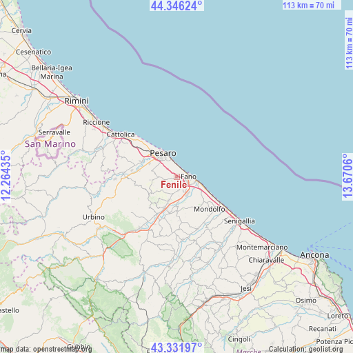
Fenile GPS coordinates[2]
43° 50' 28.536" North, 12° 58' 2.892" East
| Map corner | latitude | longitude |
|---|---|---|
| Upper-left | 44.34624°, | 12.26435° |
| Center: | 43.84126°, | 12.96747° |
| Lower-right: | 43.33197°, | 13.6706° |
| Map W x H: | 112.8×112.8 km | = 70.1×70.1mi |
| max Lat: | 47.04031° ⇑56.5% North |
| Fenile: | 43.84126° |
| min Lat: | ⇓43.5% South 35.50142° |
| min Long | Fenile | max Long |
| 6.69888° | 12.96747° | 18.48682° |
| W 67.9%⇐ | ⇒32.1% E |
Elevation
Elevation of Fenile is 33 m = 108 ft, and this is 273.7 m = 898 ft below average elevation for this country.
| Max E: |
2085 m = 6841 ft | 84.4% |
| Avg. | 306.7 m = 1006 ft | |
| Fenile | 33 m = 108 ft | |
Min E: |
-4 m = -13 ft | 15.6% |
See also: Italy elevation on elevation.city.
Geographical zone
Fenile is located in North temperate zone (between Tropic of Cancer and the Arctic Circle). Distance of this Northern Tropic circle is 2268.8 km =1409.8 mi to South.| Distance of | km | miles | from Fenile |
|---|---|---|---|
| North Pole | 5132.4 | 3189.1 | to North |
| Arctic Circle | 2526.5 | 1569.9 | to North |
| Tropic Cancer | 2268.8 | 1409.8 | to South |
| Equator | 4874.7 | 3029 | to South |


Nearby cities:
15 places around Fenile: (largest is in red/bold)
• Bellocchi
5.9 km =3.7 mi,  148°
148°
• Calcinelli
10.4 km =6.5 mi,  201°
201°
• Candelara
6.6 km =4.1 mi,  285°
285°
• Cartoceto
10.8 km =6.7 mi,  218°
218°
• Centinarola
2.1 km =1.3 mi,  122°
122°
• Cuccurano
5.4 km =3.4 mi,  187°
187°
• Fano
3.9 km =2.4 mi,  91°
91°
• Ghetto di Trebbiantico
4.2 km =2.6 mi,  338°
338°
• Lucrezia
7.9 km =4.9 mi, 196°
• Mombaroccio
10.4 km =6.5 mi,  240°
240°
• Pesaro
8.6 km =5.3 mi,  331°
331°
• Rosciano
3.8 km =2.4 mi,  136°
136°
• Tombaccia
7.2 km =4.5 mi,  107°
107°
• Villa Ceccolini
10.9 km =6.8 mi,  283°
283°
• Villagrande
9.4 km =5.8 mi,  245°
245°
Sources, notices
• [Note1] Compared only with cities in Italy existing in our database
• [Src1] Map data: © OpenStreetMap contributors (CC-BY-SA)
• [Src2] Other city data from geonames.org with taken over terms of usage.
• [Src3] Geographical zone / Annual Mean Temperature by Robert A. Rohde @ Wikipedia
