Fano geodata
Fano (The Marches) is a seat of a third-order administrative division; located in Italy in Europe/Rome (GMT+2) time zone. With population of 38,999 people, there are 186 cities with bigger population in this country. Compared to other cities in Italy, 56.5% of cities are located further ↑North; 68.4% of cities are located further ←West and 92.1% of cities have higher elevation than Fano. Note1
Administrative division(s):
- Level 1: The Marches
- Level 2: Provincia di Pesaro e Urbino
- Level 3: Fano


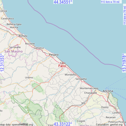
Fano GPS coordinates[2]
43° 50' 25.872" North, 13° 0' 59.94" East
| Map corner | latitude | longitude |
|---|---|---|
| Upper-left | 44.34551°, | 12.31353° |
| Center: | 43.84052°, | 13.01665° |
| Lower-right: | 43.33122°, | 13.71978° |
| Map W x H: | 112.8×112.8 km | = 70.1×70.1mi |
| max Lat: | 47.04031° ⇑56.5% North |
| Fano: | 43.84052° |
| min Lat: | ⇓43.5% South 35.50142° |
| min Long | Fano | max Long |
| 6.69888° | 13.01665° | 18.48682° |
| W 68.4%⇐ | ⇒31.6% E |
Elevation
Elevation of Fano is 14 m = 46 ft, and this is 292.7 m = 960 ft below average elevation for this country.
| Max E: |
2085 m = 6841 ft | 92.1% |
| Avg. | 306.7 m = 1006 ft | |
| Fano | 14 m = 46 ft | |
Min E: |
-4 m = -13 ft | 7.9% |
See also: Italy elevation on elevation.city.
Geographical zone
Fano is located in North temperate zone (between Tropic of Cancer and the Arctic Circle). Distance of this Northern Tropic circle is 2268.7 km =1409.7 mi to South.| Distance of | km | miles | from Fano |
|---|---|---|---|
| North Pole | 5132.5 | 3189.2 | to North |
| Arctic Circle | 2526.6 | 1570 | to North |
| Tropic Cancer | 2268.7 | 1409.7 | to South |
| Equator | 4874.6 | 3028.9 | to South |


Nearby cities:
15 places around Fano: (largest is in red/bold)
• Bellocchi
5.1 km =3.2 mi,  190°
190°
• Calcinelli
12.4 km =7.7 mi,  218°
218°
• Candelara
10.5 km =6.5 mi,  280°
280°
• Centinarola
2.4 km =1.5 mi,  244°
244°
• Cuccurano
7 km =4.3 mi, 221°
• Fenile
3.9 km =2.4 mi,  271°
271°
• Ghetto di Trebbiantico
6.7 km =4.2 mi,  306°
306°
• Lucrezia
9.7 km =6 mi, 219°
• Marotta
7.8 km =4.8 mi,  126°
126°
• Pesaro
11.1 km =6.9 mi, 313°
• Piagge
12.5 km =7.8 mi,  198°
198°
• Rosciano
3 km =1.9 mi,  206°
206°
• San Costanzo
9.3 km =5.8 mi,  150°
150°
• Solfanuccio
10.1 km =6.3 mi,  160°
160°
• Tombaccia
3.6 km =2.2 mi, 126°
Sources, notices
• [Note1] Compared only with cities in Italy existing in our database
• [Src1] Map data: © OpenStreetMap contributors (CC-BY-SA)
• [Src2] Other city data from geonames.org with taken over terms of usage.
• [Src3] Geographical zone / Annual Mean Temperature by Robert A. Rohde @ Wikipedia
