Crova geodata
Crova (Piedmont) is a seat of a third-order administrative division; located in Italy in Europe/Rome (GMT+2) time zone. With population of 370 people, there are 10394 cities with bigger population in this country. Compared to other cities in Italy, 68.3% of cities are located further ↓South; 91% of cities are located further →East and 59.1% of cities have higher elevation than Crova. Note1


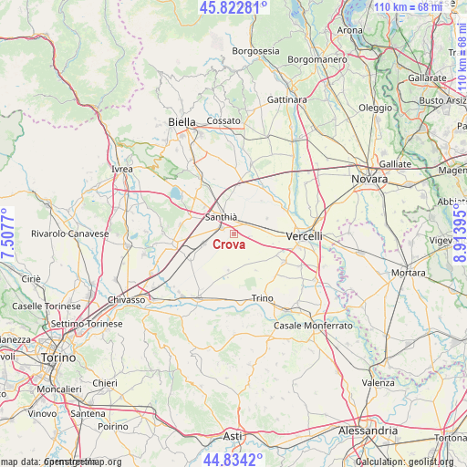
Crova GPS coordinates[2]
45° 19' 50.376" North, 8° 12' 38.988" East
| Map corner | latitude | longitude |
|---|---|---|
| Upper-left | 45.82281°, | 7.5077° |
| Center: | 45.33066°, | 8.21083° |
| Lower-right: | 44.8342°, | 8.91395° |
| Map W x H: | 109.9×109.9 km | = 68.3×68.3mi |
| max Lat: | 47.04031° ⇑31.7% North |
| Crova: | 45.33066° |
| min Lat: | ⇓68.3% South 35.50142° |
| min Long | Crova | max Long |
| 6.69888° | 8.21083° | 18.48682° |
| W 9%⇐ | ⇒91% E |
Elevation
Elevation of Crova is 170 m = 558 ft, and this is 136.7 m = 448 ft below average elevation for this country.
| Max E: |
2085 m = 6841 ft | 59.1% |
| Avg. | 306.7 m = 1006 ft | |
| Crova | 170 m = 558 ft | |
Min E: |
-4 m = -13 ft | 40.9% |
See also: Italy elevation on elevation.city.
Geographical zone
Crova is located in North temperate zone (between Tropic of Cancer and the Arctic Circle). Distance of this North polar circle is 2360.9 km =1467 mi to North.| Distance of | km | miles | from Crova |
|---|---|---|---|
| North Pole | 4966.8 | 3086.2 | to North |
| Arctic Circle | 2360.9 | 1467 | to North |
| Tropic Cancer | 2434.4 | 1512.7 | to South |
| Equator | 5040.3 | 3131.9 | to South |


Nearby cities:
15 places around Crova: (largest is in red/bold)
• Alice Castello
11.6 km =7.2 mi,  291°
291°
• Bianzè
7.4 km =4.6 mi,  249°
249°
• Borgo d'Ale
12.6 km =7.8 mi,  279°
279°
• Carisio
8.9 km =5.5 mi,  354°
354°
• Casanova Elvo
10.1 km =6.3 mi,  40°
40°
• Cavaglià
12.5 km =7.8 mi,  311°
311°
• Lignana
11.5 km =7.1 mi,  115°
115°
• Livorno Ferraris
11.7 km =7.3 mi,  242°
242°
• Olcenengo
8.6 km =5.3 mi,  64°
64°
• Ronsecco
10.1 km =6.3 mi,  148°
148°
• Salasco
4.2 km =2.6 mi,  97°
97°
• Sali Vercellese
9.5 km =5.9 mi, 104°
• San Germano Vercellese
3.6 km =2.2 mi,  51°
51°
• Santhià
5.2 km =3.2 mi,  322°
322°
• Tronzano Vercellese
3.2 km =2 mi, 293°
Sources, notices
• [Note1] Compared only with cities in Italy existing in our database
• [Src1] Map data: © OpenStreetMap contributors (CC-BY-SA)
• [Src2] Other city data from geonames.org with taken over terms of usage.
• [Src3] Geographical zone / Annual Mean Temperature by Robert A. Rohde @ Wikipedia
