Bianzè geodata
Bianzè (Piedmont) is a seat of a third-order administrative division; located in Italy in Europe/Rome (GMT+2) time zone. With population of 1,777 people, there are 4524 cities with bigger population in this country. Compared to other cities in Italy, 67.6% of cities are located further ↓South; 91.9% of cities are located further →East and 57.3% of cities have higher elevation than Bianzè. Note1


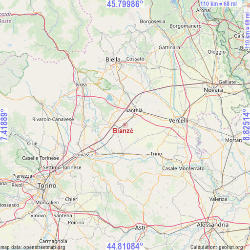
Bianzè GPS coordinates[2]
45° 18' 27.036" North, 8° 7' 19.272" East
| Map corner | latitude | longitude |
|---|---|---|
| Upper-left | 45.79986°, | 7.41889° |
| Center: | 45.30751°, | 8.12202° |
| Lower-right: | 44.81084°, | 8.82514° |
| Map W x H: | 110×110 km | = 68.4×68.4mi |
| max Lat: | 47.04031° ⇑32.4% North |
| Bianzè: | 45.30751° |
| min Lat: | ⇓67.6% South 35.50142° |
| min Long | Bianzè | max Long |
| 6.69888° | 8.12202° | 18.48682° |
| W 8.1%⇐ | ⇒91.9% E |
Elevation
Elevation of Bianzè is 185 m = 607 ft, and this is 121.7 m = 399 ft below average elevation for this country.
| Max E: |
2085 m = 6841 ft | 57.3% |
| Avg. | 306.7 m = 1006 ft | |
| Bianzè | 185 m = 607 ft | |
Min E: |
-4 m = -13 ft | 42.7% |
See also: Italy elevation on elevation.city.
Geographical zone
Bianzè is located in North temperate zone (between Tropic of Cancer and the Arctic Circle). Distance of this North polar circle is 2363.5 km =1468.6 mi to North.| Distance of | km | miles | from Bianzè |
|---|---|---|---|
| North Pole | 4969.3 | 3087.8 | to North |
| Arctic Circle | 2363.5 | 1468.6 | to North |
| Tropic Cancer | 2431.8 | 1511 | to South |
| Equator | 5037.7 | 3130.3 | to South |


Nearby cities:
15 places around Bianzè: (largest is in red/bold)
• Alice Castello
7.8 km =4.8 mi,  330°
330°
• Borgo d'Ale
7.2 km =4.5 mi,  310°
310°
• Cavaglià
11.2 km =7 mi,  347°
347°
• Cigliano
7.7 km =4.8 mi,  270°
270°
• Crova
7.4 km =4.6 mi,  69°
69°
• Lamporo
8.7 km =5.4 mi,  192°
192°
• Livorno Ferraris
4.4 km =2.7 mi,  231°
231°
• Maglione
9.5 km =5.9 mi,  297°
297°
• Moncrivello
10.3 km =6.4 mi,  285°
285°
• Salasco
11.3 km =7 mi,  79°
79°
• San Germano Vercellese
10.9 km =6.8 mi,  63°
63°
• Sant'Antonino
8.5 km =5.3 mi,  222°
222°
• Santhià
7.7 km =4.8 mi,  29°
29°
• Tronzano Vercellese
5.6 km =3.5 mi,  46°
46°
• Villareggia
11.3 km =7 mi, 270°
Sources, notices
• [Note1] Compared only with cities in Italy existing in our database
• [Src1] Map data: © OpenStreetMap contributors (CC-BY-SA)
• [Src2] Other city data from geonames.org with taken over terms of usage.
• [Src3] Geographical zone / Annual Mean Temperature by Robert A. Rohde @ Wikipedia
