Scaldasole geodata
Scaldasole (Lombardy) is a seat of a third-order administrative division; located in Italy in Europe/Rome (GMT+2) time zone. With population of 937 people, there are 6945 cities with bigger population in this country. Compared to other cities in Italy, 63.1% of cities are located further ↓South; 82.6% of cities are located further →East and 72.2% of cities have higher elevation than Scaldasole. Note1


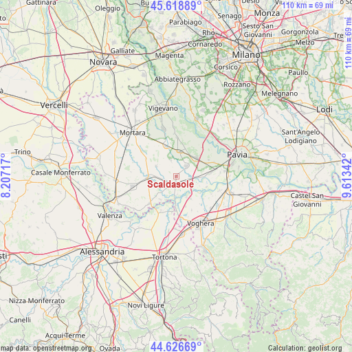
Scaldasole GPS coordinates[2]
45° 7' 29.82" North, 8° 54' 37.044" East
| Map corner | latitude | longitude |
|---|---|---|
| Upper-left | 45.61889°, | 8.20717° |
| Center: | 45.12495°, | 8.91029° |
| Lower-right: | 44.62669°, | 9.61342° |
| Map W x H: | 110.3×110.3 km | = 68.5×68.5mi |
| max Lat: | 47.04031° ⇑36.9% North |
| Scaldasole: | 45.12495° |
| min Lat: | ⇓63.1% South 35.50142° |
| min Long | Scaldasole | max Long |
| 6.69888° | 8.91029° | 18.48682° |
| W 17.4%⇐ | ⇒82.6% E |
Elevation
Elevation of Scaldasole is 87 m = 285 ft, and this is 219.7 m = 721 ft below average elevation for this country.
| Max E: |
2085 m = 6841 ft | 72.2% |
| Avg. | 306.7 m = 1006 ft | |
| Scaldasole | 87 m = 285 ft | |
Min E: |
-4 m = -13 ft | 27.8% |
See also: Italy elevation on elevation.city.
Geographical zone
Scaldasole is located in North temperate zone (between Tropic of Cancer and the Arctic Circle). Distance of this North polar circle is 2383.7 km =1481.2 mi to North.| Distance of | km | miles | from Scaldasole |
|---|---|---|---|
| North Pole | 4989.6 | 3100.4 | to North |
| Arctic Circle | 2383.7 | 1481.2 | to North |
| Tropic Cancer | 2411.5 | 1498.4 | to South |
| Equator | 5017.4 | 3117.7 | to South |


Nearby cities:
15 places around Scaldasole: (largest is in red/bold)
• Alagna
5.2 km =3.2 mi,  341°
341°
• Corana
8.3 km =5.2 mi,  146°
146°
• Cornale
9.1 km =5.7 mi,  179°
179°
• Dorno
4.5 km =2.8 mi,  44°
44°
• Ferrera Erbognone
3.8 km =2.4 mi,  252°
252°
• Galliavola
7.8 km =4.8 mi, 247°
• Garlasco
7.9 km =4.9 mi,  7°
7°
• Gropello Cairoli
8.7 km =5.4 mi,  48°
48°
• Lomello
9 km =5.6 mi,  266°
266°
• Mezzana Bigli
8.8 km =5.5 mi,  214°
214°
• Ottobiano
6.9 km =4.3 mi,  297°
297°
• Pieve Albignola
4.1 km =2.5 mi,  108°
108°
• Sannazzaro de' Burgondi
2.5 km =1.6 mi,  186°
186°
• Valeggio
4.8 km =3 mi,  306°
306°
• Zinasco Nuovo
7.1 km =4.4 mi,  92°
92°
Sources, notices
• [Note1] Compared only with cities in Italy existing in our database
• [Src1] Map data: © OpenStreetMap contributors (CC-BY-SA)
• [Src2] Other city data from geonames.org with taken over terms of usage.
• [Src3] Geographical zone / Annual Mean Temperature by Robert A. Rohde @ Wikipedia
