Lastra a Signa geodata
Lastra a Signa (Tuscany) is a seat of a third-order administrative division; located in Italy in Europe/Rome (GMT+2) time zone. With population of 11,504 people, there are 817 cities with bigger population in this country. Compared to other cities in Italy, 57.3% of cities are located further ↑North; 55.7% of cities are located further →East and 83.1% of cities have higher elevation than Lastra a Signa. Note1


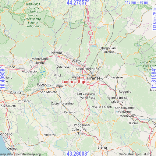
Lastra a Signa GPS coordinates[2]
43° 46' 11.928" North, 11° 6' 45.756" East
| Map corner | latitude | longitude |
|---|---|---|
| Upper-left | 44.27557°, | 10.40959° |
| Center: | 43.76998°, | 11.11271° |
| Lower-right: | 43.26008°, | 11.81584° |
| Map W x H: | 112.9×112.9 km | = 70.2×70.2mi |
| max Lat: | 47.04031° ⇑57.3% North |
| Lastra a Signa: | 43.76998° |
| min Lat: | ⇓42.7% South 35.50142° |
| min Long | Lastra a Signa | max Long |
| 6.69888° | 11.11271° | 18.48682° |
| W 44.3%⇐ | ⇒55.7% E |
Elevation
Elevation of Lastra a Signa is 37 m = 121 ft, and this is 269.7 m = 885 ft below average elevation for this country.
| Max E: |
2085 m = 6841 ft | 83.1% |
| Avg. | 306.7 m = 1006 ft | |
| Lastra a Signa | 37 m = 121 ft | |
Min E: |
-4 m = -13 ft | 16.9% |
See also: Italy elevation on elevation.city.
Geographical zone
Lastra a Signa is located in North temperate zone (between Tropic of Cancer and the Arctic Circle). Distance of this Northern Tropic circle is 2260.8 km =1404.8 mi to South.| Distance of | km | miles | from Lastra a Signa |
|---|---|---|---|
| North Pole | 5140.3 | 3194 | to North |
| Arctic Circle | 2534.4 | 1574.8 | to North |
| Tropic Cancer | 2260.8 | 1404.8 | to South |
| Equator | 4866.8 | 3024.1 | to South |


Nearby cities:
15 places around Lastra a Signa: (largest is in red/bold)
• Campi Bisenzio
6.2 km =3.9 mi,  13°
13°
• Comeana
5.1 km =3.2 mi,  300°
300°
• Ginestra Fiorentina
7.4 km =4.6 mi,  204°
204°
• Malmantile
4.1 km =2.5 mi,  231°
231°
• Mantignano-Ugnano
4.8 km =3 mi,  73°
73°
• Poggio A Caiano
6.9 km =4.3 mi,  314°
314°
• Quattro Strade
4.1 km =2.5 mi,  219°
219°
• Romola
8.8 km =5.5 mi,  152°
152°
• San Donnino
3.9 km =2.4 mi,  43°
43°
• San Martino alla Palma
3.4 km =2.1 mi,  132°
132°
• San Mauro
2.9 km =1.8 mi,  20°
20°
• San Vincenzo a Torri
7.8 km =4.8 mi,  189°
189°
• Scandicci
6.3 km =3.9 mi,  106°
106°
• Serra
7.5 km =4.7 mi, 298°
• Signa
2.8 km =1.7 mi,  344°
344°
Sources, notices
• [Note1] Compared only with cities in Italy existing in our database
• [Src1] Map data: © OpenStreetMap contributors (CC-BY-SA)
• [Src2] Other city data from geonames.org with taken over terms of usage.
• [Src3] Geographical zone / Annual Mean Temperature by Robert A. Rohde @ Wikipedia
