Belforte del Chienti geodata
Belforte del Chienti (The Marches) is a seat of a third-order administrative division; located in Italy in Europe/Rome (GMT+2) time zone. With population of 1,528 people, there are 5057 cities with bigger population in this country. Compared to other cities in Italy, 62.1% of cities are located further ↑North; 70.8% of cities are located further ←West and 53.2% of cities have lower elevation than Belforte del Chienti. Note1
Administrative division(s):
- Level 1: The Marches
- Level 2: Provincia di Macerata
- Level 3: Belforte del Chienti
Current local time in Belforte del Chienti:
06:39 PM, WednesdayDifference from your time zone: hours


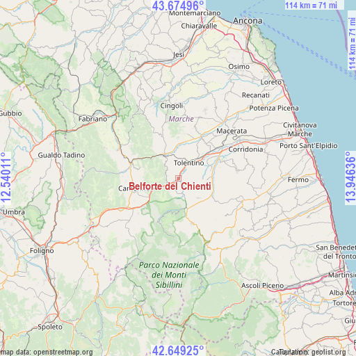
Belforte del Chienti GPS coordinates[2]
43° 9' 51.336" North, 13° 14' 35.628" East
| Map corner | latitude | longitude |
|---|---|---|
| Upper-left | 43.67496°, | 12.54011° |
| Center: | 43.16426°, | 13.24323° |
| Lower-right: | 42.64925°, | 13.94636° |
| Map W x H: | 114×114 km | = 70.8×70.8mi |
| max Lat: | 47.04031° ⇑62.1% North |
| Belforte del Chienti: | 43.16426° |
| min Lat: | ⇓37.9% South 35.50142° |
| min Long | Belforte del Ch | max Long |
| 6.69888° | 13.24323° | 18.48682° |
| W 70.8%⇐ | ⇒29.2% E |
Elevation
Elevation of Belforte del Chienti is 254 m = 833 ft, and this is 52.7 m = 173 ft below average elevation for this country.
| Max E: |
2085 m = 6841 ft | 46.8% |
| Avg. | 306.7 m = 1006 ft | |
| Belforte del Chienti | 254 m = 833 ft | |
Min E: |
-4 m = -13 ft | 53.2% |
See also: Italy elevation on elevation.city.
Geographical zone
Belforte del Chienti is located in North temperate zone (between Tropic of Cancer and the Arctic Circle). Distance of this Northern Tropic circle is 2193.5 km =1363 mi to South.| Distance of | km | miles | from Belforte del Chienti |
|---|---|---|---|
| North Pole | 5207.6 | 3235.9 | to North |
| Arctic Circle | 2601.8 | 1616.7 | to North |
| Tropic Cancer | 2193.5 | 1363 | to South |
| Equator | 4799.4 | 2982.2 | to South |


Nearby cities:
15 places around Belforte del Chienti: (largest is in red/bold)
• Caldarola
2.9 km =1.8 mi,  213°
213°
• Camporotondo di Fiastrone
4 km =2.5 mi,  152°
152°
• Cesolo
11.5 km =7.1 mi,  339°
339°
• Cessapalombo
6.3 km =3.9 mi,  169°
169°
• Colmurano
9.4 km =5.8 mi,  89°
89°
• Gualdo
13.6 km =8.5 mi,  143°
143°
• Loro Piceno
13.7 km =8.5 mi, 89°
• Pollenza
14.1 km =8.8 mi,  36°
36°
• Ripe San Ginesio
10.4 km =6.5 mi,  103°
103°
• San Ginesio
8.9 km =5.5 mi,  134°
134°
• San Severino Marche
9 km =5.6 mi,  325°
325°
• Sant'Angelo in Pontano
14.5 km =9 mi,  120°
120°
• Serrapetrona
4.5 km =2.8 mi,  287°
287°
• Tolentino
6 km =3.7 mi,  34°
34°
• Urbisaglia
11.1 km =6.9 mi,  73°
73°
Sources, notices
• [Note1] Compared only with cities in Italy existing in our database
• [Src1] Map data: © OpenStreetMap contributors (CC-BY-SA)
• [Src2] Other city data from geonames.org with taken over terms of usage.
• [Src3] Geographical zone / Annual Mean Temperature by Robert A. Rohde @ Wikipedia
