Cessapalombo geodata
Cessapalombo (The Marches) is a seat of a third-order administrative division; located in Italy in Europe/Rome (GMT+2) time zone. With population of 126 people, there are 11362 cities with bigger population in this country. Compared to other cities in Italy, 62.5% of cities are located further ↑North; 70.9% of cities are located further ←West and 74.4% of cities have lower elevation than Cessapalombo. Note1
Administrative division(s):
- Level 1: The Marches
- Level 2: Provincia di Macerata
- Level 3: Cessapalombo


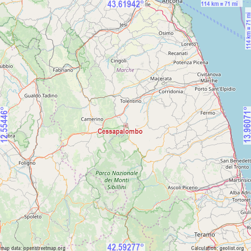
Cessapalombo GPS coordinates[2]
43° 6' 29.7" North, 13° 15' 27.288" East
| Map corner | latitude | longitude |
|---|---|---|
| Upper-left | 43.61942°, | 12.55446° |
| Center: | 43.10825°, | 13.25758° |
| Lower-right: | 42.59277°, | 13.96071° |
| Map W x H: | 114.2×114.2 km | = 71×71mi |
| max Lat: | 47.04031° ⇑62.5% North |
| Cessapalombo: | 43.10825° |
| min Lat: | ⇓37.5% South 35.50142° |
| min Long | Cessapalombo | max Long |
| 6.69888° | 13.25758° | 18.48682° |
| W 70.9%⇐ | ⇒29.1% E |
Elevation
Elevation of Cessapalombo is 444 m = 1457 ft, and this is 137.3 m = 450 ft above average elevation for this country.
| Max E: |
2085 m = 6841 ft | 25.6% |
| Cessapalombo | 444 m 1457 ft | |
| Avg. | 306.7 m = 1006 ft | |
Min E: |
-4 m = -13 ft | 74.4% |
See also: Italy elevation on elevation.city.
Geographical zone
Cessapalombo is located in North temperate zone (between Tropic of Cancer and the Arctic Circle). Distance of this Northern Tropic circle is 2187.3 km =1359.1 mi to South.| Distance of | km | miles | from Cessapalombo |
|---|---|---|---|
| North Pole | 5213.9 | 3239.8 | to North |
| Arctic Circle | 2608 | 1620.5 | to North |
| Tropic Cancer | 2187.3 | 1359.1 | to South |
| Equator | 4793.2 | 2978.4 | to South |


Nearby cities:
15 places around Cessapalombo: (largest is in red/bold)
• Belforte del Chienti
6.3 km =3.9 mi,  349°
349°
• Bolognola
13 km =8.1 mi,  191°
191°
• Caldarola
4.7 km =2.9 mi,  324°
324°
• Camporotondo di Fiastrone
2.7 km =1.7 mi,  15°
15°
• Colmurano
10.4 km =6.5 mi,  52°
52°
• Gualdo
8.4 km =5.2 mi,  124°
124°
• Pie' del Colle
11 km =6.8 mi,  217°
217°
• Ripe San Ginesio
9.7 km =6 mi,  67°
67°
• San Ginesio
5.2 km =3.2 mi,  90°
90°
• Sant'Angelo in Pontano
11.4 km =7.1 mi,  95°
95°
• Sarnano
8.8 km =5.5 mi,  158°
158°
• Serrapetrona
9.4 km =5.8 mi, 324°
• Tolentino
11.4 km =7.1 mi,  11°
11°
• Trebbio
11.6 km =7.2 mi,  226°
226°
• Urbisaglia
13.4 km =8.3 mi, 45°
Sources, notices
• [Note1] Compared only with cities in Italy existing in our database
• [Src1] Map data: © OpenStreetMap contributors (CC-BY-SA)
• [Src2] Other city data from geonames.org with taken over terms of usage.
• [Src3] Geographical zone / Annual Mean Temperature by Robert A. Rohde @ Wikipedia
