Marsciano geodata
Marsciano (Umbria) is a seat of a third-order administrative division; located in Italy in Europe/Rome (GMT+2) time zone. With population of 9,631 people, there are 982 cities with bigger population in this country. Compared to other cities in Italy, 63.8% of cities are located further ↑North; 60.7% of cities are located further ←West and 57.1% of cities have higher elevation than Marsciano. Note1


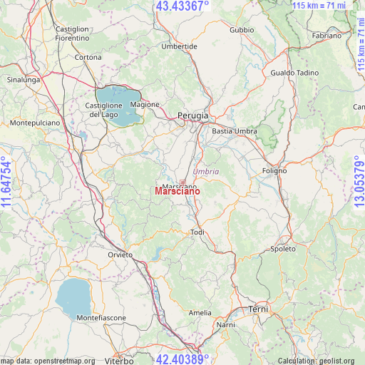
Marsciano GPS coordinates[2]
42° 55' 15.348" North, 12° 21' 2.376" East
| Map corner | latitude | longitude |
|---|---|---|
| Upper-left | 43.43367°, | 11.64754° |
| Center: | 42.92093°, | 12.35066° |
| Lower-right: | 42.40389°, | 13.05379° |
| Map W x H: | 114.5×114.5 km | = 71.1×71.1mi |
| max Lat: | 47.04031° ⇑63.8% North |
| Marsciano: | 42.92093° |
| min Lat: | ⇓36.2% South 35.50142° |
| min Long | Marsciano | max Long |
| 6.69888° | 12.35066° | 18.48682° |
| W 60.7%⇐ | ⇒39.3% E |
Elevation
Elevation of Marsciano is 187 m = 614 ft, and this is 119.7 m = 393 ft below average elevation for this country.
| Max E: |
2085 m = 6841 ft | 57.1% |
| Avg. | 306.7 m = 1006 ft | |
| Marsciano | 187 m = 614 ft | |
Min E: |
-4 m = -13 ft | 42.9% |
See also: Italy elevation on elevation.city.
Geographical zone
Marsciano is located in North temperate zone (between Tropic of Cancer and the Arctic Circle). Distance of this Northern Tropic circle is 2166.4 km =1346.1 mi to South.| Distance of | km | miles | from Marsciano |
|---|---|---|---|
| North Pole | 5234.7 | 3252.7 | to North |
| Arctic Circle | 2628.8 | 1633.5 | to North |
| Tropic Cancer | 2166.4 | 1346.1 | to South |
| Equator | 4772.4 | 2965.4 | to South |


Nearby cities:
15 places around Marsciano: (largest is in red/bold)
• Cerqueto
4.3 km =2.7 mi,  322°
322°
• Collazzone
7.3 km =4.5 mi,  107°
107°
• Collepepe
3.6 km =2.2 mi,  99°
99°
• Deruta
8.9 km =5.5 mi,  37°
37°
• Fratta Todina
7.2 km =4.5 mi,  171°
171°
• Monte Castello di Vibio
9 km =5.6 mi,  179°
179°
• Pantalla
6.6 km =4.1 mi,  143°
143°
• Ponte Nuovo
11.2 km =7 mi,  34°
34°
• Ripabianca
4.8 km =3 mi,  64°
64°
• San Niccolò di Celle
11 km =6.8 mi,  14°
14°
• San Terenziano
11.6 km =7.2 mi,  120°
120°
• San Venanzo
8.8 km =5.5 mi,  229°
229°
• Sant'Angelo di Celle
9 km =5.6 mi,  17°
17°
• Sant'Enea
9.9 km =6.2 mi,  3°
3°
• Spina
9.1 km =5.7 mi, 321°
Sources, notices
• [Note1] Compared only with cities in Italy existing in our database
• [Src1] Map data: © OpenStreetMap contributors (CC-BY-SA)
• [Src2] Other city data from geonames.org with taken over terms of usage.
• [Src3] Geographical zone / Annual Mean Temperature by Robert A. Rohde @ Wikipedia
