Cisterna geodata
Cisterna (Friuli Venezia Giulia) is a populated place; located in Italy in Europe/Rome (GMT+2) time zone. With population of 713 people, there are 8204 cities with bigger population in this country. Compared to other cities in Italy, 93.8% of cities are located further ↓South; 68.1% of cities are located further ←West and 65.3% of cities have higher elevation than Cisterna. Note1
Administrative division(s):
- Level 1: Friuli Venezia Giulia
- Level 2: Provincia di Udine
- Level 3: Coseano


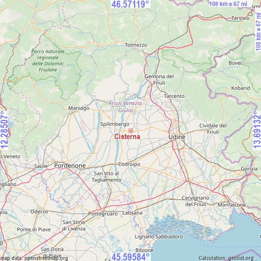
Cisterna GPS coordinates[2]
46° 5' 8.412" North, 12° 59' 17.484" East
| Map corner | latitude | longitude |
|---|---|---|
| Upper-left | 46.57119°, | 12.28507° |
| Center: | 46.08567°, | 12.98819° |
| Lower-right: | 45.59584°, | 13.69132° |
| Map W x H: | 108.4×108.4 km | = 67.4×67.4mi |
| max Lat: | 47.04031° ⇑6.2% North |
| Cisterna: | 46.08567° |
| min Lat: | ⇓93.8% South 35.50142° |
| min Long | Cisterna | max Long |
| 6.69888° | 12.98819° | 18.48682° |
| W 68.1%⇐ | ⇒31.9% E |
Elevation
Elevation of Cisterna is 126 m = 413 ft, and this is 180.7 m = 593 ft below average elevation for this country.
| Max E: |
2085 m = 6841 ft | 65.3% |
| Avg. | 306.7 m = 1006 ft | |
| Cisterna | 126 m = 413 ft | |
Min E: |
-4 m = -13 ft | 34.7% |
See also: Italy elevation on elevation.city.
Geographical zone
Cisterna is located in North temperate zone (between Tropic of Cancer and the Arctic Circle). Distance of this North polar circle is 2276.9 km =1414.8 mi to North.| Distance of | km | miles | from Cisterna |
|---|---|---|---|
| North Pole | 4882.8 | 3034 | to North |
| Arctic Circle | 2276.9 | 1414.8 | to North |
| Tropic Cancer | 2518.3 | 1564.8 | to South |
| Equator | 5124.2 | 3184 | to South |


Nearby cities:
15 places around Cisterna: (largest is in red/bold)
• Carpacco
4.3 km =2.7 mi,  328°
328°
• Coseano
2.7 km =1.7 mi,  64°
64°
• Dignano
3.7 km =2.3 mi,  266°
266°
• Flaibano
3.1 km =1.9 mi,  185°
185°
• Madrisio
6.7 km =4.2 mi, 55°
• Mereto di Tomba
5.8 km =3.6 mi,  131°
131°
• Pantianicco
7.8 km =4.8 mi,  152°
152°
• Plasencis
7.1 km =4.4 mi,  105°
105°
• Rive d'Arcano
5.7 km =3.5 mi,  36°
36°
• Rodeano
3.3 km =2.1 mi,  32°
32°
• San Vito di Fagagna
6 km =3.7 mi,  84°
84°
• Sedegliano
8 km =5 mi, 185°
• Silvella
4.7 km =2.9 mi,  87°
87°
• Spilimbergo
8 km =5 mi,  292°
292°
• Villanova
5.4 km =3.4 mi,  345°
345°
Sources, notices
• [Note1] Compared only with cities in Italy existing in our database
• [Src1] Map data: © OpenStreetMap contributors (CC-BY-SA)
• [Src2] Other city data from geonames.org with taken over terms of usage.
• [Src3] Geographical zone / Annual Mean Temperature by Robert A. Rohde @ Wikipedia
