Taggia geodata
Taggia (Liguria) is a seat of a third-order administrative division; located in Italy in Europe/Rome (GMT+2) time zone. With population of 12,762 people, there are 722 cities with bigger population in this country. Compared to other cities in Italy, 56.4% of cities are located further ↑North; 95.1% of cities are located further →East and 87.4% of cities have higher elevation than Taggia. Note1


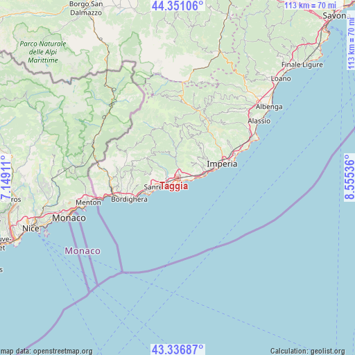
Taggia GPS coordinates[2]
43° 50' 46.032" North, 7° 51' 8.028" East
| Map corner | latitude | longitude |
|---|---|---|
| Upper-left | 44.35106°, | 7.14911° |
| Center: | 43.84612°, | 7.85223° |
| Lower-right: | 43.33687°, | 8.55536° |
| Map W x H: | 112.8×112.8 km | = 70.1×70.1mi |
| max Lat: | 47.04031° ⇑56.4% North |
| Taggia: | 43.84612° |
| min Lat: | ⇓43.6% South 35.50142° |
| min Long | Taggia | max Long |
| 6.69888° | 7.85223° | 18.48682° |
| W 4.9%⇐ | ⇒95.1% E |
Elevation
Elevation of Taggia is 24 m = 79 ft, and this is 282.7 m = 927 ft below average elevation for this country.
| Max E: |
2085 m = 6841 ft | 87.4% |
| Avg. | 306.7 m = 1006 ft | |
| Taggia | 24 m = 79 ft | |
Min E: |
-4 m = -13 ft | 12.6% |
See also: Italy elevation on elevation.city.
Geographical zone
Taggia is located in North temperate zone (between Tropic of Cancer and the Arctic Circle). Distance of this Northern Tropic circle is 2269.3 km =1410.1 mi to South.| Distance of | km | miles | from Taggia |
|---|---|---|---|
| North Pole | 5131.8 | 3188.8 | to North |
| Arctic Circle | 2525.9 | 1569.5 | to North |
| Tropic Cancer | 2269.3 | 1410.1 | to South |
| Equator | 4875.2 | 3029.3 | to South |


Nearby cities:
15 places around Taggia: (largest is in red/bold)
• Badalucco
7.9 km =4.9 mi,  356°
356°
• Castellaro
2.4 km =1.5 mi,  33°
33°
• Ceriana
7.3 km =4.5 mi,  301°
301°
• Cipressa
6.4 km =4 mi,  84°
84°
• Civezza
8.8 km =5.5 mi,  64°
64°
• Costarainera
7.2 km =4.5 mi, 82°
• Dolcedo
10.3 km =6.4 mi,  48°
48°
• Montalto Ligure
9.2 km =5.7 mi, 356°
• Pietrabruna
6.3 km =3.9 mi,  40°
40°
• Pompeiana
3 km =1.9 mi, 75°
• Riva Ligure
2.3 km =1.4 mi,  110°
110°
• San Lorenzo al Mare
9 km =5.6 mi, 84°
• San Remo
6.8 km =4.2 mi,  241°
241°
• Santo Stefano al Mare
3.7 km =2.3 mi,  103°
103°
• Terzorio
3.8 km =2.4 mi, 79°
Sources, notices
• [Note1] Compared only with cities in Italy existing in our database
• [Src1] Map data: © OpenStreetMap contributors (CC-BY-SA)
• [Src2] Other city data from geonames.org with taken over terms of usage.
• [Src3] Geographical zone / Annual Mean Temperature by Robert A. Rohde @ Wikipedia
