Castelverde geodata
Castelverde (Lombardy) is a seat of a third-order administrative division; located in Italy in Europe/Rome (GMT+2) time zone. With population of 2,903 people, there are 3116 cities with bigger population in this country. Compared to other cities in Italy, 64.7% of cities are located further ↓South; 67.8% of cities are located further →East and 79.3% of cities have higher elevation than Castelverde. Note1


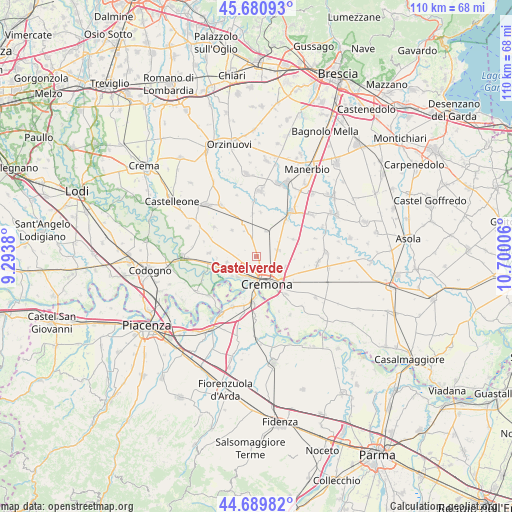
Castelverde GPS coordinates[2]
45° 11' 15.108" North, 9° 59' 48.948" East
| Map corner | latitude | longitude |
|---|---|---|
| Upper-left | 45.68093°, | 9.2938° |
| Center: | 45.18753°, | 9.99693° |
| Lower-right: | 44.68982°, | 10.70006° |
| Map W x H: | 110.2×110.2 km | = 68.5×68.5mi |
| max Lat: | 47.04031° ⇑35.3% North |
| Castelverde: | 45.18753° |
| min Lat: | ⇓64.7% South 35.50142° |
| min Long | Castelverde | max Long |
| 6.69888° | 9.99693° | 18.48682° |
| W 32.2%⇐ | ⇒67.8% E |
Elevation
Elevation of Castelverde is 53 m = 174 ft, and this is 253.7 m = 832 ft below average elevation for this country.
| Max E: |
2085 m = 6841 ft | 79.3% |
| Avg. | 306.7 m = 1006 ft | |
| Castelverde | 53 m = 174 ft | |
Min E: |
-4 m = -13 ft | 20.7% |
See also: Italy elevation on elevation.city.
Geographical zone
Castelverde is located in North temperate zone (between Tropic of Cancer and the Arctic Circle). Distance of this North polar circle is 2376.8 km =1476.9 mi to North.| Distance of | km | miles | from Castelverde |
|---|---|---|---|
| North Pole | 4982.7 | 3096.1 | to North |
| Arctic Circle | 2376.8 | 1476.9 | to North |
| Tropic Cancer | 2418.5 | 1502.8 | to South |
| Equator | 5024.4 | 3122 | to South |


Nearby cities:
15 places around Castelverde: (largest is in red/bold)
• Boschetto
3.3 km =2.1 mi,  135°
135°
• Casalbuttano
7.7 km =4.8 mi,  338°
338°
• Casanova del Morbasco
3.8 km =2.4 mi,  224°
224°
• Costa Sant'Abramo
3.3 km =2.1 mi,  225°
225°
• Cremona
6.3 km =3.9 mi,  162°
162°
• Dosimo
8.4 km =5.2 mi,  92°
92°
• Maristella
6 km =3.7 mi,  133°
133°
• Olmeneta
5.7 km =3.5 mi,  21°
21°
• Paderno Ponchielli
7.7 km =4.8 mi,  316°
316°
• Pozzaglio
4.6 km =2.9 mi,  72°
72°
• Pozzaglio ed Uniti
4.4 km =2.7 mi, 71°
• San Felice
7.8 km =4.8 mi, 129°
• Sesto Cremonese
6.6 km =4.1 mi,  258°
258°
• Sesto ed Uniti
6.6 km =4.1 mi, 259°
• Spinadesco
7 km =4.3 mi, 232°
Sources, notices
• [Note1] Compared only with cities in Italy existing in our database
• [Src1] Map data: © OpenStreetMap contributors (CC-BY-SA)
• [Src2] Other city data from geonames.org with taken over terms of usage.
• [Src3] Geographical zone / Annual Mean Temperature by Robert A. Rohde @ Wikipedia
