Castel San Pietro Terme geodata
Castel San Pietro Terme (Emilia-Romagna) is a seat of a third-order administrative division; located in Italy in Europe/Rome (GMT+2) time zone. With population of 11,081 people, there are 852 cities with bigger population in this country. Compared to other cities in Italy, 50.4% of cities are located further ↑North; 50.5% of cities are located further ←West and 73.6% of cities have higher elevation than Castel San Pietro Terme. Note1
Administrative division(s):
- Level 1: Emilia-Romagna
- Level 2: Bologna
- Level 3: Castel San Pietro Terme
Current local time in Castel San Pietro Terme:
12:41 AM, WednesdayDifference from your time zone: hours


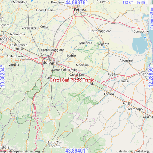
Castel San Pietro Terme GPS coordinates[2]
44° 23' 54.744" North, 11° 35' 7.656" East
| Map corner | latitude | longitude |
|---|---|---|
| Upper-left | 44.89876°, | 10.88234° |
| Center: | 44.39854°, | 11.58546° |
| Lower-right: | 43.89401°, | 12.28859° |
| Map W x H: | 111.7×111.7 km | = 69.4×69.4mi |
| max Lat: | 47.04031° ⇑50.4% North |
| Castel San Pietro Terme: | 44.39854° |
| min Lat: | ⇓49.6% South 35.50142° |
| min Long | Castel San Piet | max Long |
| 6.69888° | 11.58546° | 18.48682° |
| W 50.5%⇐ | ⇒49.5% E |
Elevation
Elevation of Castel San Pietro Terme is 80 m = 262 ft, and this is 226.7 m = 744 ft below average elevation for this country.
| Max E: |
2085 m = 6841 ft | 73.6% |
| Avg. | 306.7 m = 1006 ft | |
| Castel San Pietro Terme | 80 m = 262 ft | |
Min E: |
-4 m = -13 ft | 26.4% |
See also: Italy elevation on elevation.city.
Geographical zone
Castel San Pietro Terme is located in North temperate zone (between Tropic of Cancer and the Arctic Circle). Distance of this Northern Tropic circle is 2330.7 km =1448.2 mi to South.| Distance of | km | miles | from Castel San Pietro Terme |
|---|---|---|---|
| North Pole | 5070.4 | 3150.6 | to North |
| Arctic Circle | 2464.5 | 1531.4 | to North |
| Tropic Cancer | 2330.7 | 1448.2 | to South |
| Equator | 4936.7 | 3067.5 | to South |


Nearby cities:
15 places around Castel San Pietro Terme: (largest is in red/bold)
• Casalfiumanese
11.7 km =7.3 mi,  164°
164°
• Castel Guelfo di Bologna
8.1 km =5 mi,  62°
62°
• Dozza
5.7 km =3.5 mi,  135°
135°
• Ganzanigo
10.6 km =6.6 mi,  32°
32°
• Imola
11.1 km =6.9 mi,  113°
113°
• Maggio
7.9 km =4.9 mi,  301°
301°
• Medicina-Buda
9.8 km =6.1 mi, 25°
• Mercatale
12.4 km =7.7 mi,  266°
266°
• Osteria Grande
6.1 km =3.8 mi, 303°
• Ozzano dell'Emilia
10.1 km =6.3 mi, 300°
• Ponte Rizzoli
9.5 km =5.9 mi,  320°
320°
• Ponticelli
10.2 km =6.3 mi,  148°
148°
• Sasso Morelli
12.3 km =7.6 mi,  80°
80°
• Toscanella
4.7 km =2.9 mi, 112°
• Villa Fontana
10.8 km =6.7 mi,  9°
9°
Sources, notices
• [Note1] Compared only with cities in Italy existing in our database
• [Src1] Map data: © OpenStreetMap contributors (CC-BY-SA)
• [Src2] Other city data from geonames.org with taken over terms of usage.
• [Src3] Geographical zone / Annual Mean Temperature by Robert A. Rohde @ Wikipedia
