Medicina-Buda geodata
Medicina-Buda (Emilia-Romagna) is a seat of a third-order administrative division; located in Italy in Europe/Rome (GMT+2) time zone. With population of 8,791 people, there are 1082 cities with bigger population in this country. Compared to other cities in Italy, 50.7% of cities are located further ↓South; 51.1% of cities are located further ←West and 86.4% of cities have higher elevation than Medicina-Buda. Note1


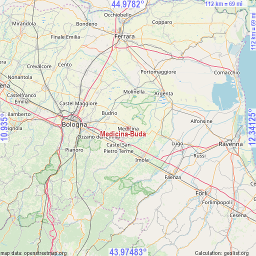
Medicina-Buda GPS coordinates[2]
44° 28' 43.212" North, 11° 38' 17.232" East
| Map corner | latitude | longitude |
|---|---|---|
| Upper-left | 44.9782°, | 10.935° |
| Center: | 44.47867°, | 11.63812° |
| Lower-right: | 43.97483°, | 12.34125° |
| Map W x H: | 111.6×111.6 km | = 69.3×69.3mi |
| max Lat: | 47.04031° ⇑49.3% North |
| Medicina-Buda: | 44.47867° |
| min Lat: | ⇓50.7% South 35.50142° |
| min Long | Medicina-Buda | max Long |
| 6.69888° | 11.63812° | 18.48682° |
| W 51.1%⇐ | ⇒48.9% E |
Elevation
Elevation of Medicina-Buda is 27 m = 89 ft, and this is 279.7 m = 918 ft below average elevation for this country.
| Max E: |
2085 m = 6841 ft | 86.4% |
| Avg. | 306.7 m = 1006 ft | |
| Medicina-Buda | 27 m = 89 ft | |
Min E: |
-4 m = -13 ft | 13.6% |
See also: Italy elevation on elevation.city.
Geographical zone
Medicina-Buda is located in North temperate zone (between Tropic of Cancer and the Arctic Circle). Distance of this Northern Tropic circle is 2339.6 km =1453.8 mi to South.| Distance of | km | miles | from Medicina-Buda |
|---|---|---|---|
| North Pole | 5061.5 | 3145.1 | to North |
| Arctic Circle | 2455.6 | 1525.8 | to North |
| Tropic Cancer | 2339.6 | 1453.8 | to South |
| Equator | 4945.6 | 3073.1 | to South |


Nearby cities:
15 places around Medicina-Buda: (largest is in red/bold)
• Budrio
10.5 km =6.5 mi,  308°
308°
• Castel Guelfo di Bologna
6 km =3.7 mi,  150°
150°
• Castel San Pietro Terme
9.8 km =6.1 mi,  205°
205°
• Dozza
13 km =8.1 mi,  180°
180°
• Ganzanigo
1.4 km =0.9 mi,  88°
88°
• Maggio
11.9 km =7.4 mi,  246°
246°
• Osteria Grande
10.8 km =6.7 mi,  238°
238°
• Ponte Rizzoli
10.3 km =6.4 mi,  261°
261°
• San Martino in Argine
12.5 km =7.8 mi,  348°
348°
• Sant'Antonio
11.6 km =7.2 mi,  32°
32°
• Sasso Morelli
10.5 km =6.5 mi,  131°
131°
• Sesto Imolese
7.5 km =4.7 mi,  106°
106°
• Toscanella
10.7 km =6.6 mi, 179°
• Vedrana
10.1 km =6.3 mi,  329°
329°
• Villa Fontana
2.9 km =1.8 mi, 307°
Sources, notices
• [Note1] Compared only with cities in Italy existing in our database
• [Src1] Map data: © OpenStreetMap contributors (CC-BY-SA)
• [Src2] Other city data from geonames.org with taken over terms of usage.
• [Src3] Geographical zone / Annual Mean Temperature by Robert A. Rohde @ Wikipedia
