Dozza geodata
Dozza (Emilia-Romagna) is a seat of a third-order administrative division; located in Italy in Europe/Rome (GMT+2) time zone. With population of 1,142 people, there are 6145 cities with bigger population in this country. Compared to other cities in Italy, 51% of cities are located further ↑North; 51% of cities are located further ←West and 60.5% of cities have higher elevation than Dozza. Note1


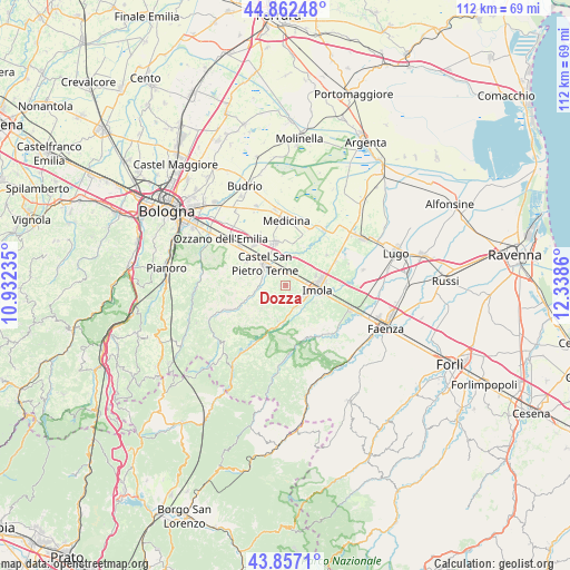
Dozza GPS coordinates[2]
44° 21' 43.02" North, 11° 38' 7.692" East
| Map corner | latitude | longitude |
|---|---|---|
| Upper-left | 44.86248°, | 10.93235° |
| Center: | 44.36195°, | 11.63547° |
| Lower-right: | 43.8571°, | 12.3386° |
| Map W x H: | 111.8×111.8 km | = 69.5×69.5mi |
| max Lat: | 47.04031° ⇑51% North |
| Dozza: | 44.36195° |
| min Lat: | ⇓49% South 35.50142° |
| min Long | Dozza | max Long |
| 6.69888° | 11.63547° | 18.48682° |
| W 51%⇐ | ⇒49% E |
Elevation
Elevation of Dozza is 159 m = 522 ft, and this is 147.7 m = 485 ft below average elevation for this country.
| Max E: |
2085 m = 6841 ft | 60.5% |
| Avg. | 306.7 m = 1006 ft | |
| Dozza | 159 m = 522 ft | |
Min E: |
-4 m = -13 ft | 39.5% |
See also: Italy elevation on elevation.city.
Geographical zone
Dozza is located in North temperate zone (between Tropic of Cancer and the Arctic Circle). Distance of this Northern Tropic circle is 2326.7 km =1445.7 mi to South.| Distance of | km | miles | from Dozza |
|---|---|---|---|
| North Pole | 5074.5 | 3153.1 | to North |
| Arctic Circle | 2468.6 | 1533.9 | to North |
| Tropic Cancer | 2326.7 | 1445.7 | to South |
| Equator | 4932.6 | 3065 | to South |


Nearby cities:
15 places around Dozza: (largest is in red/bold)
• Borgo Tossignano
9.4 km =5.8 mi,  199°
199°
• Bubano
13 km =8.1 mi,  63°
63°
• Casalfiumanese
7.3 km =4.5 mi,  187°
187°
• Castel Guelfo di Bologna
8.4 km =5.2 mi,  22°
22°
• Castel San Pietro Terme
5.7 km =3.5 mi,  315°
315°
• Fontanelice
13 km =8.1 mi,  208°
208°
• Ganzanigo
13.1 km =8.1 mi,  7°
7°
• Imola
6.2 km =3.9 mi,  92°
92°
• Medicina-Buda
13 km =8.1 mi,  0°
0°
• Osteria Grande
11.7 km =7.3 mi,  309°
309°
• Ponticelli
4.8 km =3 mi,  163°
163°
• Riolo Terme
12 km =7.5 mi,  142°
142°
• San Prospero
11.1 km =6.9 mi, 88°
• Sasso Morelli
10.1 km =6.3 mi,  53°
53°
• Toscanella
2.3 km =1.4 mi, 8°
Sources, notices
• [Note1] Compared only with cities in Italy existing in our database
• [Src1] Map data: © OpenStreetMap contributors (CC-BY-SA)
• [Src2] Other city data from geonames.org with taken over terms of usage.
• [Src3] Geographical zone / Annual Mean Temperature by Robert A. Rohde @ Wikipedia
